Abstract
We analyze the relationship between residential populations, school attendance zone boundaries (AZBs), and school enrollments in two large, countywide suburban districts, Fairfax County, Virginia, and Montgomery County, Maryland, from 1990 to 2010. A steep decline in white, school-age children and an increase in black, Hispanic, and Asian children in both neighborhoods and the schools that serve them suggests that white households reluctant to send their children to diversifying schools are exiting (or never entering) these districts entirely rather than sorting within them. AZB changes, often due to the opening of new schools, affect a large portion of both districts, but boundary changes are associated with only a small portion of increased segregation observed in both schools and neighborhoods between 1990 and 2010. Our findings speak to the complex, multidirectional relationships between demographic trends and AZBs in diversifying, growing suburbs.
Although the United States has become increasingly diverse, public K–12 schools remain largely segregated (Frankenberg et al. 2019). Suburban spaces especially have seen increases in the racial and economic diversity of their overall populations (Frey 2014), but suburban schools have isolated student populations because of a combination of factors, including shifting residential demographic patterns and segregative school attendance zone boundaries (AZBs).
In this article, we analyze changes in school enrollment, AZBs, and residential populations in Fairfax County Public Schools (Virginia) and Montgomery County Public Schools (Maryland), two diversifying and growing countywide suburban districts, emblematic of national trends, near Washington, D.C. We find a highly varied set of changes within and between our two case study districts that bely any simple narrative of how AZBs mediate the link between neighborhood demographics and school populations. The districts experienced steep decline in white, school-age children and increases in percentage of black and especially Hispanic children, complicating our analysis and suggesting that white households reluctant to send their children to diversifying schools may be exiting these two districts, or new white households with school-age children are not entering. Both counties experienced greater increases in neighborhood segregation levels between 1990 and 2000 compared with 2000 and 2010; this is also true of school segregation in Montgomery County, but in Fairfax County, school segregation increased more during the 2000s. Changing racial composition plays a critical role in the segregation increases. AZB changes combined with school openings and closures affected large portions of both school districts from 1990 to 2010, but school openings seem to be primarily desegregative in effect. Our findings demonstrate how the relationship between school and neighborhood populations has changed in suburbs experiencing substantial demographic changes. These findings challenge us to reconceptualize changing patterns of segregation in suburban spaces and schools.
THEORETICAL PERSPECTIVES
In recent decades, U.S. suburban school districts have experienced significant ethnic and racial diversification and, despite popular conceptions of suburbia, white students are no longer a majority in suburban schools in large metropolitan areas (Diamond and Posey-Maddox 2020; Frankenberg and Orfield 2012; Chen et al. 2021). Although student cross-racial exposure is typically higher in large suburban districts than in urban ones, black and Hispanic suburban students attend schools that tend to have lower percentages of white students and are perceived as lower quality than schools that white students in these districts attend (Frankenberg and Orfield 2012).
Decades of research demonstrate the harms of racially segregated schools and the benefits of integrated ones. More recently, as suburban districts have become more racially, economically, and linguistically diverse, inequality has arisen within and between schools. Segregated schools typically have fewer resources and are associated with lower student outcomes in terms of verbal and math achievement scores, educational attainment, and racial isolation later in life (Vigdor and Ludwig 2007; Reardon et al. 2019; Goldsmith 2009; Stearns 2010; Borman and Dowling 2010; Hanushek, Kain, and Rivkin 2009). Students who attend racially integrated schools have better long-term academic and social outcomes—including higher high school graduation rates, better college completion rates, higher earnings in adulthood particularly for African American students, and, for students of all races, more cross-racial friendships that are associated with long-term social and psychological benefits (Johnson 2019; Mickelson and Nkomo 2012; Pettigrew and Tropp 2008). Merely putting racially or economically diverse students in the same building is not enough to achieve integrated, equitable schools, however, as minoritized children have mixed experiences in white dominated school spaces due to within-school policies and practices that reinforce racial inequality (Lewis and Diamond 2015; Lewis-McCoy 2014). Thus efforts to diversify schools must also be accompanied by policies that foster true equity for all students.
The Importance of AZBs and Siting of New Schools Amid Suburban Growth
With the increasing ethnoracial diversity of suburban areas, questions arise about the extent to which suburban schools will diversify too (Frankenberg and Orfield 2012; Orfield and Frankenberg 2008). Although most metro-wide school segregation occurs across urban-suburban district lines (Owens and Rich 2023, this issue), within-district patterns of segregation can also contribute substantially to metro segregation, particularly in areas with large countywide districts experiencing suburban diversification (Farrell 2008). Countywide school districts have historically had a desegregative advantage over smaller, more fragmented districts, especially where counties capture urban and suburban populations (Morgan and England 1982; Orfield 1988, 1996; Bischoff 2008). However, it remains to be seen whether that potential for desegregation will be realized in growing and diversifying suburban counties like those we study.
Within the context of local demographic trends, individual school districts affect the ethnoracial composition and integration of their schools in the drawing of school AZBs and in school openings and closures. AZBs shape educational outcomes for students by determining which schools students have access to based on where they live within their district. Across the country, AZBs tend to reproduce existing patterns of residential segregation within schools (Monarrez 2019; Richards 2014), though they can also be adjusted to either exacerbate or reduce levels of segregation.
School district leaders adjust AZBs most often in response to growing, shrinking, or shifting populations. Both school closures and openings necessitate redrawing AZBs. Other times, boundaries are redrawn between existing schools. District leaders balance several priorities when rezoning, one of which should be the racial or economic characteristics of each school’s student body. Especially within newly diversifying school districts or districts with accelerating demographic change—like many of those in suburban areas—AZBs have the potential to create racially integrated schools that benefit all students.
However, AZBs represent a highly contentious area of educational policy (see Lung-Amam 2023, this issue). Although AZBs are foremost about assigning students to schools, they have taken on heightened significance because of the perception of limited seats in schools offering high opportunity (McDermott et al. 2019). Given that schools within the same district can vary widely in terms of their perceived quality, families who can afford to do so will work to access specific schools and compete for educational resources in a process of social closure (Fiel 2015). Considerations of schools—especially student composition—are an important part of the home-buying process (Holme 2002; Lareau and Goyette 2014). After all, buying a home buys access to a suite of governmental services, of which public schools are arguably one of the most important.1 Given the importance of AZBs, families—including in the Washington, D.C., metro area that we focus on—have organized to change (or prevent changes) to AZBs (Goldstein 2019; Mattingly 2019; Peetz 2020) to preserve their privilege, resulting in the creation or maintenance of segregated enclave schools (Siegel-Hawley 2013; Siegel-Hawley, Diem, and Frankenberg 2018).
The segregative effects of AZBs are likely particularly salient in newly diverse suburban contexts (Hall 2013; Delmelle 2015; Lichter, Parisi, and Taquino 2015a). In many communities, families of color arrived in significant numbers beginning in the 1990s, just as judicial—and, to some extent, political—commitment to desegregation was waning. Meanwhile, advantaged residents can exert disproportionate influence over rezoning decisions, seeking to maintain educational advantages (Siegel-Hawley, Bridges, and Shields 2017). Additionally, large suburban districts face competing policy priorities of trying to retain advantaged families who, because of their residence in more homogenous neighborhoods, did not recognize the need for (or resisted) more equitable reassignment policies that might have reduced enclaves (Frankenberg and Kotok 2013; Holme, Diem, and Welton 2014; Wiley, Shircliffe, and Morley 2012). Unlike urban districts, which have had racially diverse enrollments for longer and may have been under some type of desegregation obligation, suburban districts and their leaders may have less experience with using AZBs to further integration given the relative newness of diversity and the lack of legal history of using AZBs as a diversity tool. In suburban contexts, school boards also respond to demographic change without addressing how district decisions permitted inequality to replicate, such as describing rezoning solely in race-neutral ways and ignoring the racial inequalities they perpetuate (Grooms 2019; Holme and Finnigan 2013; Diem et al. 2016). Further, racial politics arising during school rezonings in suburban contexts often go beyond black-white binaries to involve other populations, including immigrants (Lung-Amam 2023, this issue).
The residential sorting of white families may also prevent meaningful desegregation as some move out of (or never move into) inner suburban school districts and into outer suburbs, a trend that has been described as the “suburban transition” or the “post suburban era” (Phelps 2018). Such moves may be driven by white residents acting in response to the recent diversification of inner suburbs (Parisi, Lichter, and Taquino 2019). Countywide suburban districts once included both these inner and outer suburbs, but as suburban diversification expands in geographic scope that may no longer be the case. Furthermore, commuting zones—geographic areas that describe where people live and work—have shifted quite a bit since 1990 (Fowler, Rhubart, and Jensen 2016). The normalization of longer commutes even into relatively affordable suburban employment zones may indicate that white families are moving even further away, out to exurbs, while maintaining access to suburban or urban job opportunities. Thus, although some earlier research identifies a demographic advantage where countywide districts existed for school desegregation (Ayscue and Orfield 2015), it is less clear whether that remains for suburban-only county districts.
AZBs not only shape school populations based on existing residential populations, but also influence residential populations themselves. A recent study of GreatSchools, a website that feeds into many real estate sites and is used by parents to gather information about schools, found that schools serving fewer black and Hispanic children had higher ratings (Hasan and Kumar 2019). The study found that this led affluent families to buy homes in areas with higher-rated schools, thus increasing home values, making it harder for lower-income families to access these schools, and ultimately increasing segregation. Recently, U.S. News and World Report also released its rankings of K–8 schools, which similarly reflect student demographics and may also fuel the reciprocal relationship between housing and school segregation (Barnum 2021). Because school composition both influences and is influenced by neighborhood composition, examining school and housing changes simultaneously, over time, can help untangle the complex pattern of segregation or integration.2
RESEARCH METHODS
We are interested in the relationship between residential and school segregation over time in two large, diverse suburban countrywide districts, including how district policy decisions like redrawing AZBs and siting of new schools, affects these relationships. To investigate this relationship, we ask several questions: How do school and residential populations change in each district over time? How does segregation change in neighborhoods and in schools? What role do school closures, openings, and AZB changes play in shaping these results? To answer these questions, we analyze school AZBs, neighborhood and school population data from 1990 to 2010 from two suburban counties in the Washington, D.C., metropolitan area.
Data
This analysis relies on a range of data sources across multiple years including the 1990, 2000, and 2010 Censuses, the National Center for Education Statistics (NCES) Common Core of Data for the 1989–1990, 1999–2000, and 2009–2010 periods,3 the U.S. Geologic Survey’s 1992, 2001, and 2011 National Land Cover Database (NLCD), and novel school AZB data collected through the Longitudinal School Attendance Boundary Study (LSABS).4 Each data source is discussed individually.5
The NLCD provides information on land use based on a grid of thirty square meter cells. We use this information to support efforts at interpolating population information collected at the census block level into a regular grid so that population and school data can be compared consistently over time in areas where people could realistically live (that is, excluding water bodies and open space).
The LSABS project is compiling elementary, middle, and high school AZBs from 1990, 2000, 2010, and 2020 for a national sample of K–12 school districts. We use LSABS data for elementary schools in Montgomery and Fairfax Counties for 1990, 2000, and 2010. The 2010 data rely heavily on the boundary files from the School Attendance Boundary Information System downloaded from the National Historic GIS system (NHGIS) (Manson et al. 2021). A range of documents collected from school districts and other sources were scanned and digitized to create georeferenced boundary polygons for every school in the two districts as part of the LSABS project and these polygons were then combined with point information from the NCES CCD.
The NCES Common Core of Data (NCES CCD) includes latitude and longitude of schools, school demographics including race-ethnicity and eligibility for free and reduced lunch, and school type (magnet, charter). Point information on schools’ location was carefully matched to polygons delineating school catchment areas from the LSABS project. Schools without polygons (for example, a district-wide special education school) were dropped from dataset. Schools that changed names or locations were standardized so that they could be measured distinctly from schools that opened or closed during the period. We also mapped the combined LSABS and NCES data onto the reference grid we used for population distribution to allow for better comparability.
We accessed population count data at the block level for the 1990, 2000, and 2010 decennial censuses from NHGIS (Manson et al. 2021).6 We collected variables that capture race-ethnicity by age, using information for children five to nine years old. This approximates but does not exactly match the populations counted in elementary schools—precluding exact comparisons and requiring us to use percentages in our comparison of neighborhood and school populations. Because block boundaries change across censuses and because blocks do not nest neatly inside school AZBs, we employed dasymetric interpolation to assign population counts to raster cells derived from the NLCD described. Ultimately, we aggregated this information to a grid of three-hundred-square-meter cells containing population counts by race.
Methods
In addition to descriptive characterizations of school and neighborhood segregation through tables and maps, we also employ a technique for decomposing segregation and segregation change into its constituent parts (Elbers 2021). Decomposition of segregation is not novel in analyses of neighborhood change or school segregation (see Lichter, Parisi, and Taquino 2015b; Fowler, Lee, and Matthews 2016; Fowler 2016; Taylor and Frankenberg 2021). A recent contribution by Benjamin Elbers, however, allows for multidimensional decomposition to examine the relative contribution of groups (such as race-ethnicity) and units (such as census tracts or schools). This is especially helpful in the context of rapidly diversifying suburbs because it can account for changes that are a function of population mix, distinguish between racial groups that are contributing to mixing and those that are contributing to isolation, and differentiate schools and neighborhoods that are becoming more diverse and those that are becoming more homogenous within aggregate measures of segregation. Moreover, it permits decomposition over time to understand the relative contributions of population mix, school openings and closures, and differing racial-ethnic group sorting behavior to overall segregation change.
Elbers’s (2021) method relies on calculation of M, a decomposable measure of multigroup segregation similar in many ways to the more widely utilized Theil’s H. To understand M we begin from the more familiar measure of entropy E defined as follows:

where Er refers to the entropy for a set of ethnoracial groups and pr is the proportion of each racial group in the population. E, understood in this context as racial diversity, is maximized when the proportion of each racial group is equal. From Elbers, we can then define M as

where u refers to the spatial units (neighborhoods or schools) so that the contribution of each spatial unit is understood as the difference in its entropy from aggregate racial entropy weighted by that unit’s share of the entire population.
This characterization of M has three further properties that are useful for our purposes here. First, we can define Lu, the contribution of each spatial unit to aggregate segregation, as the unweighted contribution to M.

Second, the definition of M can be transformed if we want to look at the contribution of racial groups to aggregate segregation.

Finally, Elbers advances a method of transforming the data used to generate M to retain the marginals (column marginals maintain the ratio among racial categories whereas row marginals maintain the population distribution across spatial units). By retaining the marginals, it is possible to decompose changes in segregation between times t1 and t2 into components based on the changing composition of the population, the changing spatial units, and an unexplained structural segregation (Elbers 2021, 20).

In most cases, change in structural segregation is the focus of academic interest. Changes in the units (appearing and disappearing) can be chalked up to administrative practices, here guided by political decisions. Shifting population composition has to do with the underlying weights built into segregation measures more than the measures themselves. Finally, changing ethnoracial composition in the entire county is sociologically interesting but distinct from our interest in segregation per se. Structural segregation is the remainder, that which cannot be explained by other factors just described and is the heart of what concerns us about the residential sorting of populations into homogeneous groups within diverse communities.7
For our purposes here, however, the full range of components are interesting because they all play into different aspects of the change we are trying to unpack. Specifically, it is important to understand how much of what we observe in changing segregation is driven by the entrance or exit of groups from the population and their changing locations in space. Given that our cases involve new populations distributed unevenly across the landscape, changing views on integration, opening and closing schools, and changing AZBs, these decomposition techniques are essential to grasping the relative significance of different factors.
Sites
This analysis examines two large, countywide suburban school districts in the Washington, D.C., metro area that reflect the region’s multiethnic and racially diverse populations: Fairfax County Public Schools (FCPS) and Montgomery County Public Schools (MCPS). The D.C. metro area is one of the most diverse in the country; in 2019, its population was about 45 percent white, 25 percent black, 16 percent Hispanic, and 10 percent Asian. Analysis of place-level diversity in the District of Columbia shows that, as of 2010, places within the metro represented a pretty even continuum of diversity (Fowler, Lee, and Matthews 2016). Some places were extremely diverse but others remained much more homogenous. Moreover, unlike other metros, especially in the Northeast and Midwest, most suburban parts of the D.C. metro have countywide school districts instead of smaller, municipal districts, which likely means the population within school districts, affected by AZBs and their changes, will be more diverse.
We use a collective case study design to analyze multiple suburban school districts with meaningful similarities and differences (Creswell 2013). Such purposeful sampling provides useful insight into the relationship between school AZBs and demographic change despite the difficulties of generalizing findings from nuanced settings. The neighboring school districts here are similar in both their geographic size (more than four hundred square miles each) and enrollment (size and demographics). In 1990, each had more than one hundred thousand students and now both have more than 150,000, ranking them in the top fifteen largest districts in the country (see table 1). Though similar, they provide useful variation in their respective demographics, state contexts, and policy context.
District Demographics, 1990, 2000, 2010, 2020
In many ways, the demographics and change over time in these two districts reflect suburban districts in large metros nationally. Still more affluent than public schools overall, both districts have had rising poverty since the 1990s. The districts also have rising shares of English language learners, reflecting growing immigrant populations. Although FCPS enrollment is larger and has a higher percentage of white students than MCPS enrollment, both have increasing enrollments and higher proportions of students of color, particularly among Hispanic students, now the largest group in Montgomery County Public Schools.8 Asian students are 20 percent of FCPS’s enrollment; black students are 21 percent of MCPS’s.
Fairfax County, Virginia, is southwest of Washington, D.C., and is one of the wealthiest counties in the nation; the median household income in 2020 was $124,831. The county is also known for its affluent and highly regarded school system. No longer a majority white district, FCPS enrolls large percentages of Hispanic and Asian students, and the proportion of emerging bilingual students has increased considerably. The percentage of black students has remained at just over 10 percent; by 2000, FCPS black students were the fourth largest group.
The FCPS school board resisted initial requests by the community to develop a desegregation plan in the aftermath of the Brown decision in 1954.9 At the time, Virginia adopted massive resistance in response to the decision. When the first petition to require desegregation was filed in 1957, the school board’s general position was to not take action and to rely on the state, which maintained segregation (for example, through pupil placement laws). The district then slowly implemented desegregation until a new plan in 1964, which led to the closing or conversions of several black schools; teachers were also later reassigned (Fairfax County Public Schools 1966).
In the fall of 2017, Fairfax County adopted a One Fairfax policy that applied to public schools and other public services from the county government. The policy affirmed the county’s increased diversity as a strength and stated intentions to address existing racial inequalities. The policy specifically noted the need to adopt housing policies that would encourage housing integration as well as an educational system from early childhood that provides equitable opportunity and inclusion. The policy committed the county government and school district to a series of action steps, as well as a cross-system equity-focused team.
A few months after the One Fairfax policy was adopted, the district began reviewing its policy governing its boundary change process and criteria (see Fairfax County Public Schools 2013). Virginia law permits districts to change AZBs affecting less than 15 percent of enrollment without notice, allowing for incremental boundary change. And often instead of changing boundaries and grappling with associated politics, FCPS has frequently responded to population growth by adding temporary classrooms or building additions (Woolsey 2019). Further, existing policy specifies AZB changes can be made for efficiency or effectiveness reasons, without mention of equity or diversity considerations, as is the case in many large districts. Although the draft policy as of 2020 included equitable access and racial-economic composition of students, the board’s website noted that the draft did not recommend “moving students outside of their community based on racial and socioeconomic criteria” (Fairfax County Public Schools 2021). Most recently, AZB changes approved in summer 2021 included no discussion of how the changes would affect schools’ composition (Fairfax County Public Schools 2021). Thus, there has not been much measurable action on racial segregation.
There is limited school choice in Fairfax County, largely for older students (Woolsey 2019). Fairfax also hosts Thomas Jefferson, a highly acclaimed regional magnet high school that has been the focus of intense debate over admissions strategies aimed at creating a racially diverse student body.10 At the elementary level, several schools have dual language immersion programs, and two schools host magnet programs. These schools accept neighborhood students living within their AZBs and then run separate lottery admissions for their specialized programs; thus we include them in our analysis. The county has no charter schools.
Like Fairfax, Montgomery County, Maryland, is also an affluent, countywide suburban district outside Washington, D.C. It is a large district, nearly five hundred square miles and home to a large foreign-born population. MCPS had historically been a majority white district, and, relative to Fairfax, has a higher and increasing share of African American students.
MCPS was not party to a desegregation lawsuit, and in the 1970s, the school board adopted a Quality and Integrated Education policy that eventually established magnet schools and other policies such as considering boundary adjustments if schools deviated too far from the district-wide racial composition (Eaton 1996). An earlier analysis concluded, even after controlling for district racial shifts, that segregation of schools was increasing and that some of the policies meant to ameliorate segregation may in fact have had the opposite effect (Eaton 1996). Nevertheless, the district has continued to make some efforts to address segregation and inequality. For example, although it has boasted a high-achieving enrollment overall, opportunity gaps in the district led MCPS in 2000 to devise a system in which half of the elementary schools were designated as being in the red zone, which meant that more resources flowed to these schools. These red zone schools aligned generally along I-270, which runs northwest to southeast, and, despite wide variation, tended to have higher percentages of low-income students (Schwartz 2010). Recently, MCPS commissioned a boundary study to examine patterns of school utilization and segregation across the district (Montgomery County Public Schools, n.d.). Some students spoke out in favor of the effort, decrying the existing segregation in the district’s schools even as a number of parent forums featured speakers fiercely opposed to any potential rezoning (Peetz 2019a, 2019b). The final report concluded that it would be possible to adjust school AZBs to “make the demographics of the most socioeconomically and racially isolated schools, representing about two in five schools, more similar to their three nearest neighboring schools,” while improving school utilization rates and reassigning less than 10 percent of the district’s students (WXY Architecture + Urban Design 2021, 9). The district has stated it has no current plans to rezone.
Some of the recent forums about school boundaries in MCPS have also focused on county zoning and development decisions, including moratoriums banning new housing developments in attendance zones for overcrowded schools (Reed 2019). Montgomery County has had an inclusive housing policy since the 1970s that has provided scattered-site public housing units across the county. Specifically, developers of twenty or more units are required to make 12.5 percent of them affordable to low- or moderate-income individuals (Rodgers 2018); more than twelve thousand such units now exist. Further, the county housing authority operates nearly one thousand units that have been created under this policy allowing households with extremely low-incomes access to units in virtually every school catchment area in the county. Analysis of the inclusionary housing policy found that it helped economically integrate households and that children in these households had higher academic performance than their peers in areas of higher poverty concentration (Schwartz 2010). The County Council is considering additional affordable housing efforts in this affluent county (Lyons 2021). In all, Montgomery County has taken measurable steps to achieve better residential and school diversity, but segregation persists.
Finally, the district does have some school choice options, but AZBs are the primary assignment tool for elementary schools. Twelve elementary schools have selective admissions programs for fourth and fifth grade students, and one elementary school houses a magnet program. These schools are all included in our analysis given that they use AZBs to enroll neighborhood students for their traditional classrooms. Montgomery County had no charter schools.
FINDINGS
Overall, we expect to see that rising diversity in these districts is associated with increases in neighborhood and school segregation, given trends in other diversifying suburban places (Lichter 2013). However, district decisions around school openings, closures, and AZB changes could influence segregation patterns in different ways amidst overall demographic change.
Patterns of Racial Change in Neighborhoods and Schools
We begin our presentation of results by establishing the population baselines for both neighborhoods and schools within our study area and describing the ways in which these places changed ethnoracially over time. Understanding baseline and change are critical to understanding our subsequent results on segregation and the effects of school districts’ policy choices about boundaries, openings, and closures.
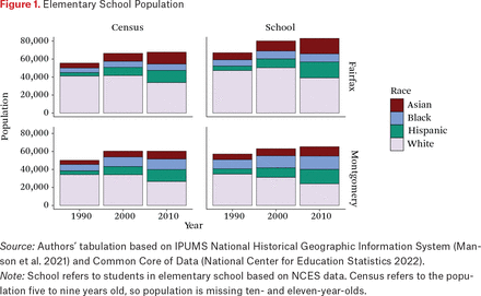
Montgomery and Fairfax Counties followed population trends common to suburbs of major metropolitan areas across the United States. Between 1990 and 2010, both counties saw increased ethnoracial diversity among young children and increased school enrollments (see figure 1). The growth was particularly high from 1990 to 2000 and slowed to some extent during the second decade we examined. During this time, both counties also experienced a decline in the white population, particularly from 2000 to 2010. In particular, the largest absolute decline (more than ten thousand white elementary students) was in the Fairfax school enrollment between 2000 and 2010 after a slight increase the preceding decade. Both districts have an increasing Hispanic population among young children and students, as do many suburban school districts across the country (Bathia et al. 2023, this issue). Montgomery County also has an increasing number of black students and children; the increase among Asian youth is more pronounced, especially from 2000 to 2010, in Fairfax County.
Elementary School Population
Source: Authors’ tabulation based on IPUMS National Historical Geographic Information System (Manson et al. 2021) and Common Core of Data (National Center for Education Statistics 2022).
Note: School refers to students in elementary school based on NCES data. Census refers to the population five to nine years old, so population is missing ten- and eleven-year-olds.
Student enrollments and census populations are not precisely comparable because the census aggregates population counts for children from five to nine years of age and therefore excludes many older children likely to still be in elementary schools, which helps explain why the Fairfax school enrollment is much higher than the census population.11 The school enrollment is modestly higher in Montgomery County as well, but the lack of larger difference may reflect more private school usage for young children there.12
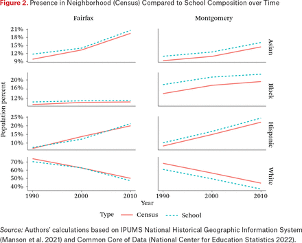
Looking more closely at the relationship between population share in neighborhoods and in schools, we can see that trends common around the country are clearly present here. White children tend to make up a higher share of the population in neighborhoods than in schools, reflecting a higher use of private and parochial schools. Notably in figure 2, however, the relationship between share of white children in neighborhoods and in schools stays pretty much constant in Montgomery County with a rather large gap. In Fairfax County, the gap is much smaller and actually falls to zero in 2000, before growing. Also worth noting in this figure are the comparatively high share of black children and students in Montgomery County and the high and rapidly growing share of Asian children and students in Fairfax County, particularly after 2000. The Hispanic enrollment in Fairfax County schools is actually lower than what is measured by the census in 2000; some of this variation may be an artifact of the U.S. Census changing its racial-ethnic classification before NCES did, which may have resulted in a lower count of Hispanic population in schools prior to the change.
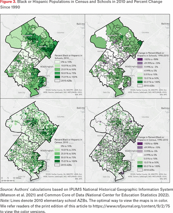
Of course, these changes were not at all uniform within the counties. Using census and school attendance data, we look at change in the percentage of black and Hispanic children in schools (figure 3, panels a and b) and neighborhoods (figure 3, panels c and d). The vast majority of the study area saw significant increases in the percentage of the population that was black or Hispanic. Notably, places that already had a significant black and Hispanic population also saw some of the largest percentage point increases.13
Black or Hispanic Populations in Census and Schools in 2010 and Percent Change Since 1990
Source: Authors’ calculations based on IPUMS National Historical Geographic Information System (Manson et al. 2021) and Common Core of Data (National Center for Education Statistics 2022).
Note: Lines denote 2010 elementary school AZBs. The optimal way to view the maps is in color. We refer readers of the print edition of this article to https://www.rsfjournal.org/content/9/2/75 to view the color versions.
In Montgomery County, the schools with majority-black or majority-Hispanic enrollments were located northeast of Washington, D.C., and stretching along the I-270 corridor. In Fairfax County, majority-black and majority-Hispanic schools were mostly in the eastern part of the county. Most black and Hispanic neighborhoods were also roughly in similar places in the counties in 1990 and 2010. Mapping 2010 elementary school AZBs onto these trends, we see that in both counties many boundary lines appear to separate neighborhoods with varying percentages of black and Hispanic residents (panel c). But AZBs do not visibly separate areas with growing and shrinking black or Hispanic populations; many catchment areas included both populations with increasing and decreasing shares of black and Hispanic children ages five to nine (panel d). This suggests that AZB lines may be more correlated with an area’s overall share of black and Hispanic residents rather than with the change in that share over time.
Changing Segregation in Neighborhoods and Schools
As seen, both the initial distribution (in 1990) and the patterns of change over time in the black and Hispanic populations were highly uneven across neighborhoods and schools. Although the overall population became more diverse, this diversity hides a wide range of outcomes vis-à-vis segregation. This section explores two areas of complexity related to our research questions. First we examine broad trends in segregation in neighborhoods and schools, disentangling the contributions of demographic change at the district level from changes in residential sorting patterns and changes in the number of schools. Next, we decompose our segregation measure geographically so that we can see the spatial variation in contribution to segregation and especially the places where we observe differences in contribution for neighborhoods and schools. Taken together, these efforts respond to our second question and inform our analysis of policy implications.
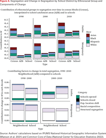
As the broader population became more diverse, both the Fairfax and Montgomery school districts saw an increase in segregation, but this increase can be decomposed into its component parts to tell a slightly more nuanced story. Over the period under consideration, multigroup segregation (as measured by M) increased substantially in both schools and neighborhoods in both counties, although we saw different patterns emerge in the 1990s and in the 2000s. We document this change in neighborhoods using census data aggregated to elementary school AZBs.14 We show these patterns of increase broken down by the contribution of four major ethnoracial groups, which are a function of the structural segregation of the group in question multiplied by its population share (figure 4a). The relatively small contribution of whites relative to their share of the population (see figure 1) suggests that, at least initially, segregated outcomes are driven by the residential patterns of other groups.15 Over time the relative share of segregation attributable to the white population increases, especially in Montgomery County, even as their share of the total population declines. This trend fits within theories of social closure arguing that as white populations become a lower proportion of a total population, white people may create enclaves to close out others, contributing more to an area’s segregation (Fiel 2013).
Segregation and Change in Segregation by School District by Ethnoracial Group and Components of Change
Source: Authors’ calculations based on IPUMS National Historical Geographic Information System (Manson et al. 2021) and Common Core of Data (National Center for Education Statistics 2022).
The drivers of the increase in segregation from 1990 to 2010 differed significantly between counties and between the decades (figure 4b). In Fairfax, school segregation increased more quickly than neighborhood segregation after 2000 but more slowly before 2000. Changing racial composition and population shifts accounted for more than half of the increase in segregation; opening schools before 2000 decreased overall segregation. After 2000, when the decrease among white enrollment in Fairfax was sharper (figure 2), racial composition accounted for a substantial share of changing school segregation. In Montgomery, structural segregation dominated changing population composition and increased at an almost identical rate in neighborhoods and schools. Unlike Fairfax though, neighborhood segregation increased more quickly than segregation in schools in both decades. Notably, in both counties, new schools had a negative impact on overall segregation from 1990 to 2000.
Taken together, the myriad changes shown in figure 4 indicate no single cause (or remedy) for unequal access to diverse schools. The drivers of segregation in schools and in neighborhoods both change over time and differ across districts. Before we turn to our final research question, with its focus on policy changes districts can undertake, we first create a typology of places where different patterns of segregation and integration could be observed in neighborhoods and schools. This geographic variation in segregation further highlights the complexity of the patterns we are working with and the different policy responses suburban districts could adopt within these large counties.
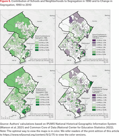
We sought to identify places where ethnoracial change in neighborhoods diverged from change in schools. Figure 5 shows the 1990 contribution to segregation for neighborhoods and schools (panels a and c) and how that contribution changed over the subsequent twenty years (panels b and d). Notably, many of the areas that contributed most to segregation in 1990 saw decreases in their contribution by 2010. This is largely a result of increasing contribution by other parts of the study area, but does disrupt any notion that segregation in neighborhoods or schools is simply a function of a few areas. Some areas that contributed most to segregation in 1990 then also contributed to increasing segregation by 2010; for example, some parts of north and western Montgomery County appear darkly shaded in panels a and c and shaded in panels b and d. However, although the maps for schools (panels a and b) and neighborhoods (panels c and d) are largely similar, they are not identical. Schools, and the neighborhoods they serve, contribute differently to segregation changes over time.
Contribution of Schools and Neighborhoods to Segregation in 1990 and to Change in Segregation, 1990 to 2010
Source: Authors’ calculations based on IPUMS National Historical Geographic Information System (Manson et al. 2021) and Common Core of Data (National Center for Education Statistics 2022). Note: The optimal way to view the maps is in color. We refer readers of the print edition of this article to https://www.rsfjournal.org/content/9/2/75 to view the color versions.
The patterns of change in figure 5 require further decomposition because the sociospatial process we are trying to understand is at least partially a question of causality and whether neighborhood change leads or lags school change. Typically, the percentage of white students in schools declines more rapidly than total population in neighborhoods because of white parents’ sensitivity toward increasing percentages of students of color (Saporito and Sohoni 2006; Frankenberg 2010). An earlier examination of suburban communities suggested that elementary schools were a leading indicator of pending demographic transition (Orfield 2002).
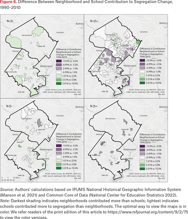
We explore this relationship by showing the difference between the values of panel 5b and panel 5d, breaking down overall trends in neighborhood and school segregation.16 Where neighborhoods contributed positively to county-level segregation and schools contributed negatively to district-level segregation (see figure 6, panel a), it is unsurprising that those neighborhoods contributed more to increasing segregation than schools did (shaded areas). In places where neighborhoods contributed negatively to segregation but schools contributed positively, the reverse is true (striped areas in panel d). Notably, places where the school segregation contribution was positive and the neighborhood segregation contribution was negative are more numerous in Fairfax County than in Montgomery County, though both counties contain a handful. Such areas in Montgomery County are concentrated in the east. In Fairfax County, they are more evenly distributed.
Difference Between Neighborhood and School Contribution to Segregation Change, 1990–2010
Source: Authors’ calculations based on IPUMS National Historical Geographic Information System (Manson et al. 2021) and Common Core of Data (National Center for Education Statistics 2022).
Note: Darkest shading indicates neighborhoods contributed more than schools; lightest indicates schools contributed more to segregation than neighborhoods. The optimal way to view the maps is in color. We refer readers of the print edition of this article to https://www.rsfjournal.org/content/9/2/75 to view the color versions.
Panel b shows places where neighborhoods and schools both contributed positively to aggregate segregation. Striped areas are places where schools contributed more to segregation than neighborhoods, again suggesting that the schools there are particularly segregative. Areas where schools were more segregative than their neighborhoods are more frequent in Fairfax County, especially in the north and eastern parts.
Finally, panel c shows places where both schools and neighborhoods contributed negatively to aggregate segregation. Once again a difference between districts is notable, such that in Fairfax the schools that were desegregative were more desegregative (had a larger negative contribution) than their neighborhoods, whereas in Montgomery the neighborhoods tended to have a larger negative contribution than their local school.
Although the relationship between school and neighborhood contributions to segregation change appears varied and complicated, one key takeaway is that neighborhood patterns of segregation do not mean destiny for school segregation, at least in these diverse countywide suburban districts. In many places, neighborhood and school segregation trends diverge.
District Policy Decisions and Segregation
In answering our final research question, we examine areas in both districts that experienced AZB changes to understand how school districts are adapting to changing neighborhoods and changing school populations. Changing school AZBs is one of the only ways school districts are allowed to adjust the composition of schools; it is equally plausible that districts could use this power to segregate or desegregate schools. We define change as any location where the school attended is different between decades, so these changes include new schools and school closures as well as boundary movements from 1990 to 2010. Particularly as enrollment increases, as is the case in these districts, AZBs may need to be frequently redrawn to adjust for capacity limits or building new schools. These changes can affect some communities more frequently than others and affect the ethnoracial segregation or integration of schools (see Parcel and Taylor 2015; Siegel-Hawley 2013; Eaton 2012; Saporito 2017).
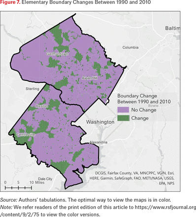
When looking at all changes for elementary schools from 1990 to 2010, a sizable share of both counties appear striped, indicating some sort of boundary change (figure 7). This is especially true in Fairfax County in areas farther from downtown Washington. The western area had more AZBs with higher shares of black and Hispanic students by 2010 (see figure 3). In Montgomery County, although some changes track along the I-270 corridor, some are in areas that did not have higher shares of black and Hispanic students (such as near Potomac).
Elementary Boundary Changes Between 1990 and 2010
Source: Authors’ tabulations. The optimal way to view the maps is in color.
Note: We refer readers of the print edition of this article to https://www.rsfjournal.org/content/9/2/75 to view the color versions.
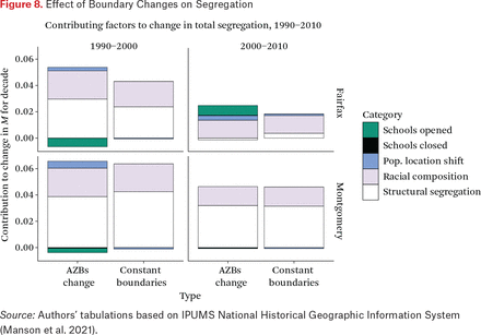
To examine the impact of boundary changes on segregation, we compared segregation in neighborhoods as they changed between 1990 and 2010 with a counterfactual in which the boundaries stayed the same. We find that in both districts, boundary changes during the 1990s resulted in a slight increase in segregation relative to the null case of no boundary change; this also held for Fairfax but not Montgomery from 2000 to 2010 (figure 8). Although the difference is small relative to total segregation, it suggests that boundary changes were not a positive force for desegregation during this period. This is concerning given that AZB changes are the factor over which local educational leaders have the most direct control. The potential of AZBs as a policy tool to make desegregative changes is not being realized, and in fact, AZB modifications are contributing to increased segregation.
Effect of Boundary Changes on Segregation
Source: Authors’ tabulations based on IPUMS National Historical Geographic Information System (Manson et al. 2021).
Decisions about where new schools are located and which schools are closed are specialized cases of AZB changes. Given population increases, we primarily examined the racial composition of elementary schools opening in each district during our study period. Previous research in other school districts finds that new school buildings may be placed in segregated neighborhoods and open with already segregated student populations. For example, Ansley Erickson (2016) finds that Metropolitan Nashville Public Schools’ desegregation plan closed schools in black neighborhoods and opened others in segregated white communities in the fringe, suburban parts of the city-suburban countywide district.
Over the years, both districts have opened several disproportionately white and disproportionately nonwhite schools (for the demographics of each new school upon opening, see table A.1). Comparison with a counterfactual in which 1990 AZBs remain constant until 2000 shows that actual AZB changes made due to school openings in the 1990s were desegregative overall in both districts (figure 8). However, school openings in the 2000s had a slightly segregative effect in Fairfax County and no real effect on overall segregation levels in Montgomery County (figure 8). Our analyses indicate how both school placement and the drawing of new AZBs contribute to segregation and desegregation patterns and are especially relevant in rapidly growing school districts like those we study here.
Finally, to better understand what changing segregation levels mean for students in schools, we examine students’ exposure to those of different races-ethnicities over time. As a complement to the evenness measure M described, the interaction index we calculate here is influenced by underlying compositional shifts. In Montgomery County, the average white student attended a school that was 70 percent white in 1990, but 53 percent white in 2010 (table 2). Even though the percentage point change is a substantial decrease, it indicates enduring segregation because white students in 2010 attended schools that were disproportionately white relative to the district overall, and this differential was greater in 2010 (white isolation was 53 percent in a district that was 38 percent white) than in 1990 (70 percent relative to 63 percent in the district). Trends are similar for white students in Fairfax County. There, the average white student’s exposure to black students hardly changed between 1992 and 2010, in part because the overall percentage of black students did not change (see table 1). In Montgomery County, the average white student’s exposure to black students increased only two percentage points between 1990 and 2000, before slightly decreasing again. Meanwhile the average black student in 2010 in both districts was attending schools that had fewer white students and more black and Hispanic students than those they attended in the 1990s. The average Asian student in both districts attended school with more Asian and Hispanic students, though their exposure to black students did not change much. Trends are similar for the average Hispanic student in both districts. Overall, increasing levels of cross-racial exposure reflect the diversification of both districts, though white isolation remains relatively high.
Racial Exposure and Isolation Indices in Elementary Schools, 1989–2010
DISCUSSION
Although segregation between districts—including in suburban areas—has been documented (see Owens and Rich 2023, this issue), it is important to examine inequality within suburban school districts, especially as they become increasingly racially and ethnically diverse. We study here one ubiquitous mechanism that has the potential to ameliorate inequality—AZBs—within two geographically sprawling suburban districts to see whether these districts can realize more equitable, integrated distribution of students across schools and neighborhoods.
Montgomery County and Fairfax County Public Schools, though adjacent to one another in the Washington, D.C., metro area, have different histories of housing and school desegregation and different demographics. Yet they also are similarly large, are growing, and have declining white populations. The decrease in white students—and the similar decrease in residential white populations—may reflect two potential factors: either white families are leaving these public school districts or white households with school-age children are choosing not to enter these districts, perhaps opting for more distant and homogeneous districts. This is consistent with literature that suggests white families may be leaving suburban counties closest to urban centers in response to recent diversification (Lichter, Thiede, and Brooks 2023; Parisi, Lichter, and Taquino 2019; Zhang and Ruther 2020) or choosing not to enter them altogether (Ellen 2000). This trend may also be particularly likely at the elementary level given that this is when many parents decide whether to invest in a district or choose another option (Lareau and Goyette 2014). Future research may investigate the population trends in the counties neighboring Montgomery and Fairfax to better understand where white families with young children in the D.C. metro area are moving, as well as their usage of non–public school options.
Our detailed examination of the contributing factors to segregation in both schools and neighborhoods showed a complex taxonomy of relationships that changed over time and across space. This complexity is consistent with our theoretical understanding of the interrelationship between housing markets and school quality. Significantly, our engagement with this complexity suggests that caution is warranted in making claims about what exactly might be driving segregation at any particular time and place. Our typology pairing the contributions of schools and neighborhoods to segregation appears to be a useful starting point for better understanding this complexity and warrants further examination on a case study basis.
Our analysis also illustrates the clustering of black and Hispanic populations in these counties and the extent to which elementary AZB changes affect swaths of the districts. Amid population growth and change in composition, boundary changes occurred often in both districts and contributed some to increasing segregation in both. AZB changes due specifically to school openings mostly contributed to decreasing segregation in both districts. However, variation in school and neighborhood segregation trends is wide both within and between these districts, and future research may analyze case studies of changes in more specific areas. Moreover, it is crucial that aggregate measures of segregation in schools and neighborhoods are examined in detail because so much of the change in these measures is conditioned on changes that are spatially complex and intertwined with broad patterns of demographic change.
Dedicated study of these trends within suburban contexts is important for several reasons. First, just as urban districts designed policies in attempts to attract or retain white families during the era of mandatory reassignment for desegregation, diversifying suburban districts today may be motivated to remain particularly responsive to advantaged families’ desires. These districts may be fearful of losing white students and associated funding, or hope to attract such families amid the suburban options that include much more homogenous districts (Frankenberg and Kotok 2013; Siegel-Hawley 2013). In particular, they may adjust AZBs in ways that privilege white or advantaged families over others by creating and protecting enclave schools. These forces may be even more complex in suburban districts that have less policy history of explicitly race-conscious housing or school efforts, stemming in part from their historical lack of diversity. In contrast, urban districts may have a history of legal or political desegregation efforts that make them more likely to implement voluntary school desegregation or have integration efforts remaining in place. Likewise, urban areas may have more affordable housing efforts than suburban areas challenged by the need for regional implementation of housing policy and by the resistance of affluent, white residents (Girouard 2023). Even in Montgomery County, a place that has made several efforts to expand inclusive housing, lack of affordability continues (Lyons 2021). Civil rights groups might also be advocating for more transparency and equality or greater social safety nets in urban areas than in higher poverty or higher black suburban areas (see Allard and Pelletier 2023, this issue). Meanwhile, suburban districts often have race-neutral rationales for avoiding wide-scale efforts to redraw more equitable AZBs, citing as barriers, for example, sprawl and transportation time, particularly as public transit is less widespread in suburbia (Murphy and Allard 2015; McArdle and Acevedo-Garcia 2022).
Such trends require us to rethink the advantage of countywide school districts (Morgan and England 1982; Orfield 1988, 1996), especially those in urban-adjacent suburban contexts. Though still quite large in terms of geographic space, suburban countywide districts may not maintain their diversity if white families continue to avoid schools with more students of color. The enlargement of commuting zones and development of many exurban areas may result in farther-out suburban districts playing the same role that districts like Fairfax or Montgomery Counties had decades ago.
Finally, this exploratory analysis of two districts helps demonstrate the potential of longitudinal AZB data. Until recently, little has been known about how AZBs have changed over time, stemming in part from a lack of data (Asson et al. 2022). Our analysis suggests the importance of collecting and preserving historical boundary files. The debate about boundary adjustments has attracted attention in districts around the country, including very recently in the two districts studied here. Policymakers are hampered by the lack of systemic, longitudinal evidence about even basic questions: How often are boundaries changed? Where? What are their effects? This may be especially likely in suburban districts that quite frequently need to change boundaries due to growth. Given the ways in which boundaries affect students’ experiences and household wealth alongside community goals of integration, careful examination is long overdue. We recommend greater transparency of AZB data to allow for cross-sector study of boundaries and potential changes by urban planners as well as educational leaders.
Appendices
Demographics of Newly Opened Elementary Schools
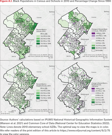
Black Populations in Census and Schools in 2010 and Percentage Change Since 1990
Source: Authors’ calculations based on IPUMS National Historical Geographic Information System (Manson et al. 2021) and Common Core of Data (National Center for Education Statistics 2022).
Note: Lines denote 2010 elementary school AZBs. The optimal way to view the maps is in color. We refer readers of the print edition of this article to https://www.rsfjournal.org/content/9/2/75 to view the color versions.
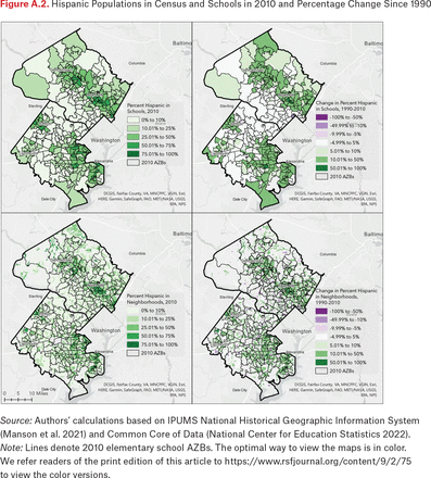
Hispanic Populations in Census and Schools in 2010 and Percentage Change Since 1990
Source: Authors’ calculations based on IPUMS National Historical Geographic Information System (Manson et al. 2021) and Common Core of Data (National Center for Education Statistics 2022).
Note: Lines denote 2010 elementary school AZBs. The optimal way to view the maps is in color. We refer readers of the print edition of this article to https://www.rsfjournal.org/content/9/2/75 to view the color versions.
FOOTNOTES
↵1. Even as school choice options have proliferated in the last few decades, the vast majority of students attend their zoned school (National Center for Education Statistics 2019).
↵2. Many districts have caveats on their website about the posted AZB maps (where available) being approximate and subject to change; a bill was pending in the Maryland legislature that also required realtors to notify home-buyers that the school assignments for a given property were subject to change. This is indicative of how important this knowledge is for some residents.
↵3. Virginia did not report enrollment counts by race-ethnicity until the 1992–1993 school year, which we use here instead of 1990.
↵4. For more detail on the study, including data and research tools see the LSABS website (https://lsabs.geog.psu.edu).
↵5. We recognize that the data harmonization efforts described are too short to permit replication or careful critique of the assumptions built into our data. A complete replication script is available on request from the authors.
↵6. We do not analyze 2020 Census data due to its late release. We focus on race because of the historical context of boundary lines separating children by race and because race but not class variables are available by census blocks.
↵7. We use Elbers’s term structural segregation while recognizing it implies that this component of total segregation is a function of structural forces, which is not necessarily true. We believe this component is most closely linked to the sociological processes of interest in the study of segregation because it is the remainder after controlling for other factors. We also believe much of this segregation can be attributed to social, economic, and historical structures shaping residential settlement patterns. However, we do not intend to imply that individual choice or other nonstructural mechanisms are excluded from this component.
↵8. This article focuses on changes from 1990 to 2010, but we include demographic data for the two districts through 2020 to demonstrate how the changes continued beyond the period analyzed here.
↵9. Oliver Brown, et al. v. Board of Education of Topeka, et al., 347 U.S. 483 (1954).
↵10. This school is not included in our analysis because we focus only on elementary schools; it is, however, currently the focus of litigation regarding “race-neutral” admissions policies aimed at increasing racial diversity of students.
↵11. Each district had small, targeted pre-K programs in some schools that may include four-year-olds since 2000.
↵12. Additionally, analysis of Private School Survey data and private school enrollment from the 2010 ACS suggests somewhat higher private school use in Montgomery County than Fairfax County.
↵13. When disaggregating change in black and Hispanic populations between 1990 and 2010 (see figures A.1 and A.2), the increase in the black or Hispanic population in certain schools and neighborhoods in Fairfax is largely driven by the growing number of Hispanic residents. In Montgomery, however, both groups contribute more evenly to the increase in the black or Hispanic population, particularly in the northeast area of the county. In both counties, areas of declining black or Hispanic population are typically the result of a decline in the black population.
↵14. Following earlier work (Taylor and Frankenberg 2021), we prefer the results by AZB because they are fundamentally linked to schools as the catchment area from which school populations are drawn, but we retain the census block measures here for comparison.
↵15. This does not mean that the responsibility for segregation does not fall on the white population. Partially, the allocations we observe are a function of the sensitivity of multigroup segregation measures to changes in the distribution of smaller groups (Martin and Fowler 2018). Beyond that sensitivity, the conditions driving residential sorting have segregated other groups more than the white population.
↵16. However, we are comparing school populations with the neighborhood population ages five through nine rather than to the total.
- © 2023 Russell Sage Foundation. Frankenberg, Erica, Christopher S. Fowler, Sarah Asson, and Ruth Krebs Buck. 2023. “Demographic Change and School Attendance Zone Boundary Changes: Montgomery County, Maryland, and Fairfax County, Virginia, Between 1990 and 2010.” RSF: The Russell Sage Foundation Journal of the Social Sciences 9(2): 75–103. DOI: 10.7758/RSF.2023.9.2.04. This material is based on work supported by the National Science Foundation under Grant No. 1918277 and Penn State University. We thank former graduate and undergraduate assistants including Hope Bodenschatz, Ian Burfoot-Rochford, and Annie Maselli. Direct correspondence to: Erica Frankenberg, at euf10{at}psu.edu, Pennsylvania State University, College of Education, 200 Rackley Building, University Park, PA 16802, United States.
Open Access Policy: RSF: The Russell Sage Foundation Journal of the Social Sciences is an open access journal. This article is published under a Creative Commons Attribution-NonCommercial-NoDerivs 3.0 Unported License.


