
Abstract
Recognition is growing that criminogenic neighborhood effects may not end at the borders of local communities, that neighborhoods are located relative to one another in ways that shape local crime rates. Inspired by this insight, this research explores the changing spatial distribution of race and income around a location and determines how such changes are associated with crime patterns and trends in neighborhoods in Los Angeles. We examine how changes from 2000 to 2010 in the income composition, racial composition, and intersection of these two constructs are linked with changes in levels of crime across local areas. We find that neighborhoods experiencing greater increases in spatial inequality in a broader area (two and a half miles around the neighborhood) experience greater increases in crime levels in the focal area over the decade, and that this pattern is strongest for neighborhoods simultaneously experiencing increasing average household income or increasing inequality. We also find that neighborhoods simultaneously experiencing increases in inequality and racial-ethnic heterogeneity experience increases in crime.
Most neighborhood crime studies focus on the effects of community-level conditions on crime within the communities where these conditions exist. For the most part, this literature has been silent about the possibility that community-to-community effects may not be bound by geographic proximity, that what occurs in neighborhoods may be affected by conditions external to them (Mears and Bhati 2006, 510). For some, this is problematic given that “many intervention efforts have failed because they did not adequately address the pressures toward crime in the community that derive from forces external to the community in the wider social structure” (Morenoff, Sampson, and Raudenbush 2001, 552).
More recently, however, researchers are recognizing the importance of studying communities as part of a broader social context. Along these lines, researchers examine spillover effects of violence leading, for example, to similar rates of violence among geographically contiguous communities (for example, Morenoff, Sampson, and Raudenbush 2001; Raleigh and Galster 2014). Other researchers consider the displacement of crime from one area to another due to an intervention targeting a specific area (for example, Weisburd and McEwen 1998). And still other researchers determine whether crime “hot spots” have spillover effects, with violence diffusing from these areas to geographically proximate communities (for example, Sherman, Gartin, and Buerger 1989). These are all excellent developments in the quest to identify and model “unbounded community effects” (Mears and Bhati 2006, 511), yet this literature does not sufficiently consider whether local area social conditions, particularly racial composition and income inequality, influence violence in spatially neighboring communities. That is, rather than simply asking whether crime in nearby areas impacts crime in a specific neighborhood (Hipp 2007; Morenoff, Sampson, and Raudenbush 2001), we can ask whether the sociodemographic characteristics of nearby areas impact the level of crime in a neighborhood (Kubrin and Hipp 2014; Peterson and Krivo 2010).
This general gap in scholarship has some notable exceptions. Recent research by Daniel Mears and Avinash Bhati (2006), Ruth Peterson and Lauren Krivo (2010), Patrick Sharkey (2014), and Elizabeth Griffiths (2013), for example, considers how spatial inequality plays an important role for social change in neighborhoods. In all of these studies, researchers find that, in varying ways, some neighborhoods experience a significant “spatial disadvantage,” which may have serious implications for their crime rates (Sharkey 2014, 909).
In this study, we build on the growing literature by taking up recent calls to “consider the ways in which individual neighborhoods are embedded within highly stratified urban landscapes that may influence the risks and opportunities to which individuals are exposed throughout different stages of the life course” (Sharkey 2014, 937). In particular, we examine the relationship between the changing racial and income composition of the neighborhood, and nearby areas, and changes in neighborhood crime rates. The study is conducted on neighborhoods in the city of Los Angeles from 2000 to 2010. We make several innovative contributions to the literature.
Our first contribution is to move beyond administrative units for defining neighborhoods and instead use egohoods, as recently introduced by John Hipp and Adam Boessen (2013). Egohoods are overlapping concentric circles that surround each block in the city. The egohood approach builds on insights from the mental mapping literature, the social networks literature, the daily activities pattern literature, and the travel to crime literature. Egohoods are conceptualized as waves washing across the surface of cities, as opposed to independent units with non-overlapping boundaries. These spatially overlapping units more appropriately capture the true amount of social interaction between residents of various groups.
A second innovation is that whereas the growing body of spatial neighborhood research has focused on the relationship between nearby disadvantage and neighborhood crime (primarily based on socioeconomic measures but sometimes on the share of minorities in a neighborhood), we construct and use measures of income distribution (inequality) and racial-ethnic heterogeneity. We employ these measures to assess the relationship between inequality and heterogeneity in the neighborhood, and nearby, with crime rates.
Third, a limitation of existing literature on the relationship between spatial inequality and crime is the frequent use of cross-sectional analyses and the treatment of this relationship as static. We argue instead that it is necessary to explore this potentially dynamic relationship with longitudinal data to better understand how spatial inequality and crime are related. A novel contribution, therefore, is to use longitudinal data and models to explore the consequences of changes in neighborhood characteristics for changing levels of crime.
Finally, an important consideration is the potential limitation of focusing on inequality solely within a neighborhood and a small surrounding area. Rather, the level of inequality in a much broader area may also have important consequences. Given evidence in the literature that higher levels of inequality in larger units such as cities affect crime in those units (see, for example, Blau and Blau 1982; Messner and Golden 1992), a natural question is whether inequality at larger scales will impact crime levels in local neighborhoods. Our innovation is to explore this possibility by focusing on whether any change in inequality in a broader area surrounding an egohood is associated with the change in crime in the egohood itself.
NEIGHBORHOODS, SPATIAL INEQUALITY, AND CRIME
Scholars working within the social disorganization theory framework often focus exclusively on the impact of structural conditions on crime within neighborhoods. In line with this approach, neighborhoods with higher levels of economic disadvantage, residential instability, and racial-ethnic heterogeneity are posited to have more social disorganization and hence more crime. Although this research has provided considerable insights, a limitation is that it often neglects conditions in nearby areas. Given the well-documented finding that offenders travel distances to crime that frequently exceed the typical size of the neighborhoods used in such studies (for example, Rossmo 2000), this approach likely overlooks an important component of the social processes generating crime in neighborhoods by failing to account for conditions in nearby areas. Fortunately, researchers are increasingly recognizing the importance of taking into account the effect of nearby areas (Mast and Wilson 2013; Mears and Bhati 2006; Popkin et al. 2012).
Despite this recent push to consider spatial areas surrounding neighborhoods, research rarely considers the presence of spatial inequality. We define spatial inequality as inequality that exists across areas without specific boundaries. Inequality more generally is a concept that fundamentally refers to a specific unit, for example, the level of inequality for a city, a county, or a country. Alternatively, spatial inequality refers to the case where units are more difficult, or even impossible, to explicitly define. Spatial inequality, then, refers to inequality that occurs not in previously defined non-overlapping units (for example, cities or counties) but rather across overlapping units based on some distance from a neighborhood. Although some researchers measure the level of inequality in neighborhoods (Crutchfield 1989; Hipp 2007; Hipp and Yates 2011; Messner and Tardiff 1986), the boundaries of neighborhoods themselves are quite contested and uncertain. Thus, if the scale at which the social process of inequality affects levels of crime is not consistent with the boundaries of certain units such as neighborhoods or cities, then measuring the level of inequality contained in various subareas of a city—spatial inequality—is critical. This is generally known as the modifiable areal unit problem (Openshaw and Taylor 1979).
Only a handful of studies have begun to address the issue of how the spatial pattern of concentrated disadvantage across the landscape might be important; nonetheless, these studies have not explicitly measured inequality. For example, Sharkey (2014) descriptively explores the spatial patterning of economic disadvantage by the racial composition of neighborhoods. Using national data from the 1970–2000 Censuses, Sharkey integrates spatially lagged measures of neighborhood characteristics into an analysis of neighborhood inequality (measured at the census tract level) to produce a more comprehensive picture of the residential environments surrounding different racial and ethnic groups, including their neighborhoods as well as those that border them. He notes a distinct spatial pattern in which black middle-class neighborhoods were more likely to be located near poorer neighborhoods than were white middle-class neighborhoods. Although his study does not focus on the consequences of these spatial patterns for neighborhood crime rates, it does highlight the importance of such patterns.
In another set of studies, Peterson and Krivo (2009, 2010) explore the spatial patterning of neighborhoods, measured as tracts, based on racial composition and concentrated disadvantage using data from the National Neighborhood Crime Study. In their study of neighborhoods in ninety-one U.S. cities at one point in time, the authors (2010) evaluate whether the character of neighboring areas—reflected by levels of disadvantage, residential instability, immigration, community investments, and white residents—accounts for differentials in crime over and above differences produced by the internal character of neighborhoods. Although they do not measure inequality per se, they do find that the level of economic disadvantage in nearby areas was positively related to crime levels in the focal neighborhood. Moreover, they find that while white neighborhoods benefit from the dual privileges of low internal disadvantage and embeddedness within a context of other white and advantaged areas, African American and Latino neighborhoods suffer a double jeopardy—they are at risk of greater violence stemming from their own internal, often highly disadvantaged, character and they bear the brunt of isolation from violence-reducing structures and processes because they are surrounded by disadvantaged areas (2010, 104).
Finally, Mears and Bhati (2006) examine whether resource deprivation (measured using an index combining the percentage of families with children headed by females, percentage of the resident population below the poverty level, unemployment rate, median household income, and median family income) contributes not only to local area violence but also to violence in geographically contiguous (and to noncontiguous but socially similar) communities in Chicago. Despite their focus on the spatial and social patterning of disadvantage, they did not measure inequality. Still, Mears and Bhati find that higher resource deprivation is associated with higher homicide rates, regardless of spatial location. Collectively, these studies push our thinking regarding the importance of concentrated disadvantage in nearby areas but what remains necessary is to explicitly consider the relationship between spatial inequality and crime—the focus of the current research.
Theoretical and Methodological Challenges
Despite the relative lack of research, theoretical reasons why spatial inequality may have important consequences for neighborhood crime exist. In social disorganization theory, for example, economic differences between residents are expected to reduce social interactions and subsequent levels of informal social control (Hipp 2007; Kubrin and Weitzer 2003). In routine activities theory and its geographic expression in crime pattern theory, to the extent that the wealthy represent more attractive targets and the poor are more likely to be offenders due to limited economic resources, the close proximity of these groups—which reflects spatial inequality—is expected to generate more crime (Rountree and Land 1996; Smith, Frazee, and Davison 2000). Finally, relative deprivation theory posits that economic inequality entails conflict of interest over the distribution of resources, which spells a potential for violence (Blau and Blau 1982). Inequality can lead members of the disadvantaged group to feel deprived and therefore they are more likely to respond by committing crime (Agnew 1999; Messner and Golden 1992; Taylor and Covington 1988).
Despite these theoretical arguments, empirical support in the literature documenting this relationship is relatively scant. This is likely due to methodological limitations of existing research rather than to a failing of these theories. As Hipp and Boessen (2013) explain, a feature of nearly all constructed neighborhoods in existing research is defining neighborhood boundaries such that they yield similarity within the neighborhood and generate difference across neighborhoods. This approach has strong implications for assessing the impact of spatial inequality; effectively, the boundaries of such neighborhoods attempt to remove all inequality within neighborhoods. The consequence is that studies of neighborhood inequality and crime often find a minimal relationship given that most of the spatial inequality in the larger area has been defined away (Crutchfield 1989; Messner and Tardiff 1986).
Hipp and Boessen (2013) suggest two possible solutions. One is to explicitly model spatial inequality across units such as census tracts. This approach at least attempts to recapture some of the spatial inequality that was systematically removed in defining neighborhoods. A second, and better, solution Hipp and Boessen ultimately implemented is to use a definition of neighborhoods that does not rely on non-overlapping boundaries—an approach they term egohoods. This approach considers egohoods to be centered on a block and to include some area surrounding the block to capture the activity patterns of residents. The result is that egohoods are overlapping “waves washing across the surface of cities” (Hipp and Boessen 2013, 287). An egohood takes a block as the center point and then incorporates all other blocks within a particular-sized buffer to be part of it.
Egohoods are distinct from other approaches that might appear the same at first blush. For example, some research has measured levels of inequality in existing units as well as in nearby units (Raleigh and Galster 2014). However, such approaches still measure inequality based on non-overlapping units that are typically predefined (by the U.S. Census) and therefore treat the units as being appropriate for measuring inequality. The egohood approach differs in that it combines small discrete units (blocks) into larger units, and then computes the level of inequality in these larger, overlapping units. Another strategy that appears similar to the egohoods approach is what Hipp and Boessen (2013) refer to as the individual social environment (ISE) perspective. In the ISE approach, the focus is on how some environment measured as the buffer around a person’s residence affects the individual. This approach is common in the public health literature (Brownson et al. 2009) and is explored using data in a Scandinavian context (Andersson and Musterd 2010). This approach also underlies the segregation measures that Sean Reardon and his colleagues developed (2008). The egohoods approach differs in that it does not posit that this surrounding area acts on the block at the center of the buffer as is done in the ISE approach, but rather that the entire buffer operates as an ecological unit of interest.
Hipp and Boessen (2013) show that employing egohoods as the unit of analysis resulted in a model that better predicts the location of crime than a model using non-overlapping units such as tracts did. Particularly notable is their finding that the relationship between inequality and crime was extremely strong in the egohoods approach, but nonexistent when using census tracts, highlighting the methodological limitation of prior research using traditional units to test this relationship. They also show that the ISE approach found essentially no such effect of inequality. Hipp and Boessen also discover that the racial-ethnic heterogeneity-crime relationship was often stronger when employing egohoods as the unit of analysis. Indeed, heterogeneity is conceptually similar in key ways to inequality; to the extent that neighborhoods are defined based on racial homogeneity, then such neighborhoods artificially understate the racial heterogeneity across the social environment. Egohoods appropriately capture this heterogeneity and therefore are better able to detect the possible relationship with crime rates.
Although Hipp and Boessen (2013) compare results using egohoods with different sized buffers, it was beyond the scope of their study to explore whether inequality levels in the area surrounding the egohood had any additional impact on crime rates within the egohood, something we address in the current study. Such spatial inequality can be conceptualized in different ways. One approach compares the average socioeconomic status (SES) in the egohood to that in the surrounding area, allowing one to test whether the difference in the average SES in the two locations has an impact on crime levels in the egohood. This approach, however, ignores the level of inequality within the egohood or in the surrounding area. Therefore, a second approach tests whether inequality in the surrounding area impacts crime in the egohood and a variant of this approach considers whether this nearby inequality is accentuated when inequality is high within the egohood itself.
Another important extension for exploring the spatial inequality-crime relationship is to move beyond static, cross-sectional approaches and instead to focus on change in neighborhoods. Given that theories such as defended neighborhoods theory (Grattet 2009; Green, Strolovitch, and Wong 1998) argue it is the change in neighborhood composition that has critical consequences for crime, cross-sectional models assuming a system in equilibrium are unable to capture such dynamic processes. Likewise, whereas relative deprivation theory (Agnew 1999; Hipp 2007; Messner and Golden 1992; Taylor and Covington 1988) focuses on how perceptions of inequality may lead to a sense of injustice and hence more crime, it may be that changes in inequality levels are particularly salient to residents and, therefore, may have the strongest impact on changes in crime levels. Longitudinal data that explicitly measure such changes are needed to assess this claim.
Beyond changes in inequality is the likely importance that changes in the racial-ethnic composition have for crime. Occasional research has explored the relationship between racial-ethnic change and neighborhood crime (Green, Strolovitch, and Wong 1998; Kubrin 2000), but next to no studies have considered whether the spatial patterning of this racial change is consequential. In particular, it may be that racial-ethnic churning, when accompanied by increasing inequality, has a particularly pronounced relationship with changes in crime. This may occur because simultaneous changes in the racial composition as well as the economic distribution may be perceived as a strong threat to the stability of the neighborhood, resulting in more pronounced withdrawal from the neighborhood and hence lowered collective efficacy. We explore this possible interaction effect in the analyses.
Broader Spatial Impact
We have so far considered only that neighborhood inequality and inequality of nearby areas might affect neighborhood crime levels. Yet spatial inequality may play out on a larger geographic scale with consequences for neighborhood crime. Given theories focusing on the consequences of inequality at larger scales, this is certainly a plausible suggestion.
Various theories posit why spatial inequality at a larger scale might impact levels of crime. We highlight two broad perspectives. First, higher levels of inequality in a larger community reduce the level of social capital among residents, resulting in residents who are less willing to provide resources to more disadvantaged neighborhoods that would allow them to address crime problems (Putnam 1995). A consequence is that this broader scale inequality would generate higher crime levels in neighborhoods. We might also expect this spatial inequality to result in higher crime rates in lower-income neighborhoods, given their inability to obtain resources to combat crime and disorder from the broader community.
A second possible mechanism is that higher levels of inequality across a broader spatial area create a sense of injustice among some residents, the result of which would be more offenders in the environment (Blau and Blau 1982). Relative deprivation theory posits that feelings of injustice can result from inequality, but defining the appropriate reference group, especially geographically, is particularly challenging (Hipp 2007). It may be that the level of inequality within a neighborhood, or nearby, is not the proper scale at which such feelings of injustice are engendered if residents take into account inequality at a larger spatial scale. If such perceived injustice indeed creates more offenders, and offenders have specific spatial patterns in where they offend as evidenced in the journey to crime literature (Rossmo 2000), then we would expect to see higher levels of crime in egohoods. That is, residents may perceive this spatial inequality as structural inequality that reduces their opportunities and therefore, be less willing to pursue educational opportunities that could enable employment in high-quality mainstream jobs. To the extent that a lack of quality employment changes the calculus of residents in choosing between employment in the mainstream economy and crime (Bushway 2011), this would indeed result in more offenders.
Notably, nearly all studies exploring inequality at larger scales also have measured crime rates at similarly large geographic scales (for example, Blau and Blau 1982; Harer and Steffensmeier 1992; Messner and Golden 1992). Thus, researchers have typically failed to explore whether inequality at a larger scale has consequences for crime levels in certain types of neighborhoods within the larger area. We might expect, for example, that the most vulnerable areas—those that are more structurally disadvantaged and socially disorganized—are more likely to be negatively affected by greater inequality in the broader spatial area around them, in large part because these areas lack the internal dynamics to combat crime. This implies an interaction effect, which we assess in the analyses.
Another limitation of this literature is that studies typically use politically determined units of analysis (such as cities, counties, and so on). In relatively dense urban areas, it is questionable whether city boundaries provide a substantively important break in the social environment between cities (for a more complete discussion of this issue, see Hipp and Roussell 2013). If, in fact, social interactions among residents—as well as offenders—transgress city boundaries, then analyses that assume these boundaries capture substantively important units may impose incorrect assumptions. This issue is similar to the earlier discussion of the problem with defining neighborhoods. One solution is consistent with the egohoods approach and uses boundaries around various neighborhood units, but with a much larger-sized buffer (Hipp and Roussell 2013). Although Hipp and Aaron Roussell (2013) suggest drawing large-scale buffers around each neighborhood in a community, they lack the fine-grained crime data we use in this study to explore whether this larger-scale spatial inequality is related to crime in the local neighborhood.
It also may be that changes in spatial inequality in the broader area have important consequences. As inequality increases at the larger spatial scale, the impact the increase has on residents’ perceptions may be particularly strong, reducing their sense of social capital as well as their sense of “being in it together.” Despite these theoretical possibilities, we are aware of no studies that explore this question.
Before turning to a description of our data and methods, we consider a complication—that crime itself can play a role in neighborhood change. It can do so because crime induces residential mobility in general, induces disproportionate residential mobility by higher income residents, and induces disproportionate residential mobility by white residents. Regarding general mobility, a burgeoning literature shows that crime can lead to residential mobility (Dugan 1999; Xie and McDowall 2008). Neighborhood studies have also detected this pattern. Census tracts in Chicago with high numbers of homicides experienced population losses over time (Morenoff, Sampson, and Raudenbush 2001), and a study of neighborhoods across thirteen cities found that higher levels of crime led to population loss and increased vacancies ten years later (Hipp 2010a). Regarding disproportionate mobility based on economic resources, studies find that crime in neighborhoods can lead to disproportionate mobility based on economic resources, which will lead to lower average income and lower home values in these neighborhoods. For example, neighborhoods with higher rates of crime have lower home values (Buck and Hakim 1989; Schwartz, Susin, and Voicu 2003; Thaler 1978), and neighborhoods experiencing increasing levels of crime also experience decreasing relative home values (Hipp, Tita, and Greenbaum 2009; Tita, Petras, and Greenbaum 2006). Evidence also suggests disproportionate mobility by race-ethnicity of residents. To the extent that racial-ethnic minorities have limited access to certain neighborhoods, they may be less able to leave a neighborhood with more crime and more likely to enter one. For example, evidence shows that black homeowners are more likely to enter more disadvantaged neighborhoods independent of their socioeconomic resources (Deng, Ross, and Wachter 2003). Studies also find that such disproportionate mobility by minorities is related to victimization experiences for residents on a block (Xie and McDowall 2010), the perception of crime among residents on a block (Hipp 2010b), and levels of violence in the broader neighborhood (Hipp 2011). Longitudinal studies of neighborhoods in Chicago find that higher delinquency rates were associated with more nonwhites at the next time point (Bursik 1986), and that increasing homicide rates were associated with more black residents ten years later (Morenoff and Sampson 1997). Finally, a study of neighborhoods across thirteen cities likewise indicates that higher levels of violence were associated with higher proportions of African Americans ten years later (Hipp 2010a). This literature suggests that certain neighborhood structural characteristics may be endogenous to crime. Specifically, residential instability, poverty, and the presence of racial-ethnic minorities are all potentially affected by levels of neighborhood crime.
Yet we argue that the pattern is more complicated when considering distributional measures such as economic inequality and racial-ethnic heterogeneity. If anything, we would expect these measures to decrease in neighborhoods with more crime. That is, if higher income residents are more likely to leave a neighborhood because of its higher crime rates, then the neighborhood will not only become poorer over time but will have lower levels of inequality (given that mostly low-income residents remain in the neighborhood). The logic is the same for racial-ethnic heterogeneity: to the extent that white households are disproportionately leaving a neighborhood, it will transition into a neighborhood with more racial-ethnic minorities but less racial-ethnic heterogeneity. Given that our analytic technique is descriptive, we do not attempt to disentangle these relationships by using instrumental variables. We merely raise these points to highlight that we are particularly unlikely to detect a positive relationship between the change in inequality in a neighborhood and the change in crime given these previously observed mobility patterns. Furthermore, it is particularly difficult to predict how crime in local neighborhoods might systematically affect the level of inequality in broader area. Nonetheless, our analytic strategy is one simply trying to describe these patterns.
DATA AND METHODS
Our study area is the city of Los Angeles, an ideal location given levels of racial and ethnic heterogeneity and large disparities in income levels. This study site allows us to explore the patterns of spatial inequality in a city whose sprawling suburban growth is representative of newer Sunbelt cities that have blossomed since the end of World War II in the United States.
Data
Crime data come from the Los Angeles city police department. The dependent variables are created from crime reports officially coded and reported by the police department. We classified crime events into five Uniform Crime Report crime types: aggravated assault, robbery, burglary, motor vehicle theft, and larceny. We averaged these measures over three years at the beginning (2000–2002) and the end (2009–2011) to minimize yearly fluctuations. Given that we know the actual location of all crime events, we were able to aggregate this information into egohoods. We do not compute these measures as crime rates because doing so would generate missing values for observations with no population. We instead residualize these results by directly including population in the models.
Unit of Analysis: Egohoods, and Surrounding Area
The notion of egohoods, first introduced by Hipp and Boessen (2013), begins by identifying each block in the city and drawing a buffer around each individual block. This buffer represents the egohood for a particular block and includes all blocks whose centroids are contained in this buffer. Thus, whereas the U.S. Census uses tracts, block groups, and blocks—all of which are based on a common population size—egohoods are based on a common area size. For this study, we used a buffer of one-quarter mile given Hipp and Boessen found that this sized egohood often revealed a relatively stronger relationship with crime relative to larger buffers. We also, however, take into account the area surrounding the egohood. For variables that the census aggregates to blocks, it is straightforward to sum all of the blocks within an egohood to compute the measures. The city of Los Angeles includes 29,157 egohoods, one for each block.
A novel contribution of the present study is not only to compute egohoods, but also to compute information on the area surrounding these egohoods. Conceptually, these areas can be thought of as donuts; where the egohood captures a particular sized area around a block (quarter-mile buffers in this study), we also measure the next quarter mile radius around the egohood as a spatial area of interest (the donut).
Constructing the Measures
The covariates in the models come from data collected by the 2000 U.S. Census, the 2007–2011 American Community Survey five-year estimates, and the Southern California Association of Governments, which contains land use data. We aggregate the data to egohoods at the beginning and end time points, and then compute difference variables for all variables described in this section.
We capture change in the economic environment of the egohood with two measures: average household income and household income inequality. To construct the average income measure, at each time point we first assign household incomes to the midpoint of their reported range (the census only reports household incomes in particular ranges), and compute the average income for residents from this information.1 We then compute the difference in this measure over the two time points. Household income inequality is measured as the standard deviation (SD) of the logged household income. We compute the midpoints of the income bins, log transform these values, multiply them by the number of observations in each bin, compute the mean logged household income, and determine the standard deviation of income based on these values. We then calculate the difference in this measure at the two time points.
A challenge for constructing the inequality measures is that the census data regarding income is aggregated to block groups. Where Hipp and Boessen (2013) use a population-weighted approach to apportion such data to blocks, we use a more principled imputation approach for our inequality measures. Our approach exploits the fact that the census provides information on the income distribution by racial-ethnic group in each block group and provides information on the composition of racial-ethnic groups in each block. To get the representation (R) of group g of G groups in a particular block, we compute the proportion of group members in the block group who live in a particular block:

where gb is the population of group g in the block (b) of 1 to G groups and gg is the population of group g in the block group (g). To obtain an estimate of the number of persons for an income category (IC) in the block (b) in a particular income category q of Q categories provided by the census for group A, we multiply the number of persons in a bin for the block group (g) by the group representation (R) in the block:

After computing equation (2) for each of the G groups, we generate estimates of the number of persons in each income category for each of the groups in the blocks. These can be used to aggregate the information of all blocks in the egohood and then to compute inequality measures by racial group. We use this information for each of the separate groups and sum them together within each block, and then sum them over all the blocks in the egohood to compute the overall level of inequality in the egohood (as the standard deviation).
To capture the possible disruptive effects of a lack of oversight from single-parent households, we construct a measure of the change in the percentage of single-parent households. Although researchers often combine this measure into a scale of concentrated disadvantage that might include average income, we keep these two measures separate to assess their independent relationship with changing crime rates. The correlation between these measures for our change variables is not as high as for cross-sectional measures: these change variables are correlated at –0.60 in egohoods and –0.68 in the surrounding area. With our large sample, we are able to empirically distinguish between these two relationships.
We measure the changing racial-ethnic composition of the egohood using three approaches: the percentage in various racial-ethnic categories; racial-ethnic heterogeneity; and racial-ethnic churning (Pastor, Sadd, and Hipp 2001). The change in the racial-ethnic composition is captured by measures of the change in the percentage African American, Latino, and Asian (with percentage white and other race as the reference category). We measure racial-ethnic heterogeneity with the Herfindahl index of the same five racial-ethnic groups at each time point, and then compute the difference over the two time points. We measure ethnic churning of the same five groups as
where G represents the proportion of the population of ethnic group j out of J ethnic groups at time t (2010) and time t-1 (2000) in egohood k. This yields a measure of the degree of racial-ethnic transformation that occurred in the tract during the decade (this is a sum of squares of differences and we take the square root to return it approximately to the original metric) (Hipp and Lakon 2010). If racial-ethnic composition does not change, it will have a value of zero.
These measures are conceptually different in how they represent change in the racial-ethnic composition of an egohood. The parameters for the composition measures are capturing the change in crime given a change in the composition of a particular group; thus, the coefficient for the change in percentage black shows the change in crime when a neighborhood experiences an increase in the percentage black and an equal decrease in the percentage white or other race (given that this is the reference category). This parameterization implies that a similar increase in the percentage white or other race along with a decrease in the percentage black will have an opposite relationship with the crime rate. As such, it presumes that something about the specific group moving in will be related to the crime rate. In contrast, the ethnic churning measure posits that any change in the racial-ethnic composition of an egohood will have an equal relationship with the change in crime. Thus, for example, a neighborhood that experiences a 10 percentage point increase in any group will experience the same change in crime regardless of which group is moving in. This implies that something about change in the racial composition in and of itself is related to crime rates; indeed, such churning may reduce collective efficacy and therefore result in more crime (Sampson, Raudenbush, and Earls 1997). Finally, the parameter for the change in racial-ethnic heterogeneity implies that change in the racial-ethnic composition will have a distinctly different relationship with crime when heterogeneity is increasing in the egohood than when it is decreasing. For example, a 10 percentage point increase in blacks in a neighborhood that is 30 percent black and 70 percent white will result in an increase in the level of heterogeneity but the same 10 percentage point increase in blacks in a neighborhood that is 70 percent black and 30 percent white will result in a decrease in the level of heterogeneity. This parameterization tests whether these types of change have differential associations with the change in crime.
To minimize the possibility of obtaining spurious results, we include several additional measures that may be related to the change in crime in egohoods. Given prior work suggesting that home owners are more willing to provide social control capability, we include a measure of the change in the percentage owners in the egohood. Evidence indicates that vacant units can be crime generators (Kubrin and Hipp 2014; Rice and Smith 2002; Smith, Frazee, and Davison 2000) and we therefore construct a measure of the change in the percentage vacant units. Life-course literature suggests that the ages sixteen to twenty-nine are the prime ages of offenders. We therefore construct a measure of the change in the percentage ages sixteen to twenty-nine in the egohood. To capture the presence of nearby persons, we include a measure of the change in population in the egohood (given the constant areal size of egohoods, this is effectively a measure of population density).
Because certain land use types can be crime generators (Kubrin and Hipp 2014; Stucky and Ottensmann 2009), we construct measures of the change in the percentage of land area that is one of six types of land use: office, industrial, retail, residential, vacant, and other (such as parking lots, parks, cemeteries, and so on).
We also construct similar measures for the quarter-mile area surrounding each egohood by computing similar measures in half-mile egohoods and then subtracting the quarter-mile egohood values. Finally, we compute measures of the socioeconomic status of the broader area by computing the average income and inequality in a 2.5-mile egohood of the block. This broader area captures a much larger context. For example, whereas the average population for a quarter-mile egohood in the study area is 2,130 persons and for a half-mile egohood is 8,814 persons, it is just under 200,000 for a 2.5-mile egohood.2 Thus, these measures are indeed capturing a quite broad context. The summary statistics for the variables used in the analyses are presented in table 1.
Methods
The outcome measures represent the change in the number of crime events between the first and last time points. Given that they can have negative values, it is not feasible to estimate the models as negative binomial regression models. We instead estimate linear regression models. The first set includes the main effects of our variables of interest. The second set assesses whether the relationships between changing inequality and changing crime rates are moderated by certain characteristics. We test several moderating relationships. First, we create a multiplicative measure of inequality in the egohood and inequality in the surrounding area to determine whether this spatial patterning moderates the results. Second, we assess whether changing inequality and racial-ethnic heterogeneity operate in tandem by constructing multiplicative measures of inequality and racial-ethnic heterogeneity in the egohood, and in the surrounding quarter mile. Third, we examine whether the relationship of the change in inequality in the egohood or surrounding area is moderated by the level of inequality in the broader 2.5-mile egohood by constructing multiplicative interactions. Finally, we examine whether the level of inequality within 2.5 miles has the strongest impact on low-income egohoods by constructing a multiplicative interaction. By constructing difference variables, our fixed-effects models eliminate the influence of time-invariant unobserved characteristics of blocks and egohoods. They do not, however, remove the possibility of endogeneity. For this reason, we treat these results as descriptive of these inequality patterns.
RESULTS
The models assess the relationship between the change in our inequality measures and the change in crime over the decade. Turning first to the relationship with changing average income, we detect a relatively strong relationship in the egohood but an even stronger relationship for the surrounding buffer (see table 2). Egohoods experiencing an increase in average household income simultaneously experience decreases in aggravated assaults, robberies, and burglaries over the decade, controlling for the other measures in the models. A 1 SD increase in average household income is associated with between 0.027 and 0.042 SD decreases in these crime types. This could alternatively reflect a feedback effect of crime onto the level of income in the neighborhood. There is also a spatial pattern, given that egohoods surrounded by areas with falling average household incomes also experience an increase in all crime types during the decade. This is a strong relationship, and much stronger than that of income change within the egohood itself, because a 1 SD increase in average income in the surrounding area is associated with anywhere between 0.095 SD fewer motor vehicle thefts to 0.29 SD fewer robberies. Note the additional relationship with the increasing presence of single-parent households, even after accounting for the change in the average income, because egohoods experiencing an increase in single-parent households also experience sharp increases for all crime types during the decade (between 0.06 and 0.137 SDs). An additional spatial pattern is evident, because egohoods experiencing an increase in single-parent households in the surrounding area experience sharp increases in aggravated assaults and motor vehicle thefts as well as an increase in the other crime types.
The relationship between increasing inequality in the egohood and crime rates is modest. Egohoods with increasing inequality experience significantly decreasing robbery and larceny rates during the decade, holding constant the other measures. Furthermore, increasing inequality in the surrounding area has a negative relationship with these crime types, which is opposite expectations.
Whereas no evidence indicates that increasing inequality in the egohood or surrounding quarter mile is associated with higher levels of crime in an egohood, the economic conditions of the even broader 2.5-mile surrounding area have a quite strong association. An egohood with a 1 SD increase in inequality in the surrounding 2.5-mile area is associated with anywhere from a 0.046 SD increase in burglaries to a 0.174 SD increase in aggravated assaults. Likewise, an egohood with a 1 SD increase in average income in the surrounding 2.5-mile area will experience, on average, anywhere from 0.062 SD fewer robberies to 0.131 SD fewer motor vehicle thefts. These associations are quite strong, suggesting that accounting for this broader context is imperative.
The findings also reveal that changes in the racial-ethnic composition of the egohood are related to changes in the crime rate. However, the pattern differs across crime types and measures of racial change. For example, the relationship with ethnic churning is quite strong for aggravated assaults, even after controlling for changes in specific groups or changes in the level of racial-ethnic heterogeneity. A 1 SD increase in ethnic churning in an egohood is associated with a 0.111 SD increase in aggravated assaults, a 0.02 SD increase in robberies, and a 0.03 SD increase in motor vehicle thefts. Yet such neighborhoods also experience a 0.02 SD decrease in larcenies, holding constant the other measures. The actual change in the racial-ethnic composition matters: neighborhoods that experience an increase in percentage black and a simultaneous decrease in percentage white or other race are more likely to experience an increase in violent crime but a decrease in property crime. Again, this relationship with violence could also reflect disproportionate mobility out of the neighborhood by white residents. And neighborhoods that experience an increase in percentage Latino and a simultaneous decrease in percentage white or other race are more likely to experience increases in robberies, burglaries, and larcenies, which may also reflect, at least to some extent, disproportionate mobility. Finally, a neighborhood experiencing a 1 SD increase in racial-ethnic heterogeneity experiences, on average, a 0.037 SD increase in aggravated assault and 0.024 SD increase in larcenies. It is hard to explain this relationship in terms of disproportionate mobility given that prior evidence would imply that higher levels of crime would reduce levels of heterogeneity, at least in the long-term.
The change in the racial-ethnic composition of the surrounding area also appears related to crime levels. On the one hand, increasing ethnic churning in the surrounding area is associated with modest increases in aggravated assaults, but decreases in larcenies (and no change in the other crime types). On the other hand, increasing racial-ethnic heterogeneity in the surrounding area is associated with greater increases in all crime types in the egohood. A 1 SD increase in nearby racial-ethnic heterogeneity is associated with anywhere from a 0.034 SD increase in robberies to a 0.073 SD increase in aggravated assaults. Changes in the actual composition of the racial groups nearby have differential relationships: whereas increases in the percentage Latino nearby (compared to percentage white and other) are associated with greater increases in three of the crime types, increases in the percentage Asian nearby (compared with percentage white and other) are actually associated with greater decreases in all crime types. Likewise, increases in percentage black nearby (versus percentage white and other) are associated with greater decreases in all crime types (except aggravated assault), controlling for the other measures in the models.
Moderating Relationships with Inequality
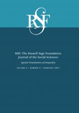
We next explore whether the relationship between changes in inequality and crime rates in an egohood is moderated by the characteristics of the surrounding quarter mile area. The results for the models that include these interactions are shown in table 3. We find that the relationship between increasing inequality in the egohood and crime rates is attenuated when there are greater increases in inequality in the nearby area for robberies and larcenies. Figure 1 plots this relationship for changes in the robbery rate for egohoods with low, average, and high changes in inequality in the egohood or the nearby area (1 SD below the mean, the mean, and 1 SD above the mean, respectively). Egohoods with greater decreases in nearby inequality have the largest increases in robbery rates, as evidenced by the top line in this figure. Moreover, these egohoods will experience an even larger increase in robberies if they themselves are experiencing increasing inequality. In contrast, an egohood experiencing increasing inequality but that is surrounded by areas with increasing inequality is more likely to experience decreases in robberies (as shown in the bottom line in this figure). The plot for the larceny model looked similar (not shown).

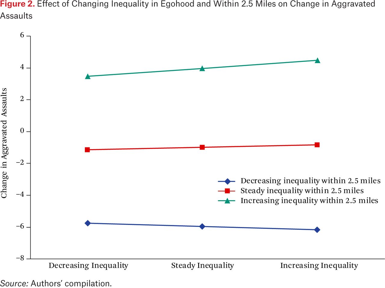
When plotting the interactions between individual egohoods and the greater area (2.5 miles), we find that the broader context has a much stronger relationship with changes in crime rates than does the nearby context. For example, figure 2 demonstrates that the positive relationship with increasing inequality in the surrounding 2.5 miles dwarfs the relationship of changing inequality in the egohood itself (that is, the gap between the lines is much greater than is the difference in the steepness of the slopes). Nonetheless, when egohoods experience an increase in inequality, aggravated assault increases more, on average, when inequality is increasing in the surrounding 2.5-mile area. The pattern is similar when plotting the relationship for robberies or burglaries (not shown).

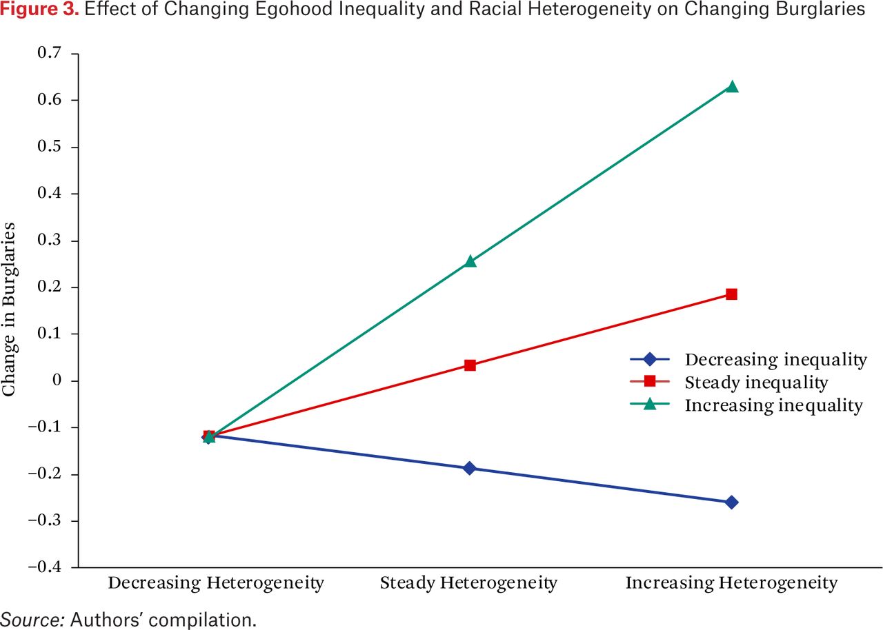
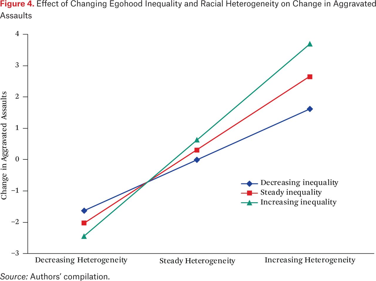
We next assess whether changing inequality has different associations with crime rates when it is accompanied by changing racial-ethnic heterogeneity. We find consistent evidence that all crime types increase more in egohoods that are simultaneously experiencing larger increases in inequality and racial-ethnic heterogeneity. For example, figure 3 illustrates that whereas the relationship between increasing racial-ethnic heterogeneity in the egohood and burglary rates is relatively flat in egohoods experiencing decreasing inequality, egohoods that are simultaneously experiencing increases in racial-ethnic heterogeneity and inequality experience the sharpest increases in burglary. The pattern for motor vehicle theft is similar (not shown). In the aggravated assault model, figure 4 shows that the largest increases were also found in egohoods experiencing a simultaneous increase in inequality and racial-ethnic heterogeneity, but egohoods experiencing increasing inequality simultaneously with decreasing racial-ethnic heterogeneity experienced the largest decreases in aggravated assault. The pattern for larceny, and to a lesser extent robbery, looks similar (not shown).


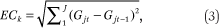
Finally, we assess whether low-income egohoods within areas of increasing spatial inequality experience the largest crime increases. The detected pattern was the opposite: egohoods with increasing average household income experience the largest crime increases when they are experiencing larger increases in inequality in the surrounding 2.5 miles. This relationship was robust for all crime types except motor vehicle theft. The plot for aggravated assault is shown in figure 5 and demonstrates that aggravated assault is highest in egohoods surrounded by increasing spatial inequality (the top line in the graph), but that it is higher if the egohood is experiencing increasing income (the right side) rather than decreasing income (the left side). The pattern is similar for robbery, burglary, and larceny (not shown).
CONCLUSION
We explore the relationship between spatial inequality and neighborhood crime rates using several innovations to the literature. Our study emphasizes the importance of considering the spatial distribution of inequality rather than focusing only on inequality within specific geographic units. We also take a longitudinal approach by explicitly examining the change in Los Angeles neighborhoods over ten years. In using the spatially overlapping approach of egohoods to measure neighborhoods, we find that changing levels of inequality in the broader 2.5-mile area are related to increasing levels of nearly all crime types in the egohood. Thus, we find that conceptualizing spatial inequality on various spatial scales is important. We summarize the key findings.
Racial-ethnic change in the egohood, and the surrounding area, had a strong association with how crime changed in the egohood. We explore racial-ethnic change using three approaches: change for specific groups, change of any type, and change that increases heterogeneity. The most robust relationships are for changing heterogeneity, given that egohoods that experienced increasing racial-ethnic heterogeneity in them, or in the surrounding area, experienced consistent increases in crime over the decade. An important implication of this pattern is that it is less likely that crime could actually induce racial-ethnic heterogeneity. Whereas existing literature has shown that crime can, at least to some extent, increase the racial minority composition of a neighborhood, there is no reason to expect it to increase heterogeneity. In fact, heterogeneity will increase in the earliest stages of in-movement of a group but will decrease in the latter stages. Thus, our modeling strategy captures general racial turnover (churning) and increases of specific groups, and these showed weaker associations with changes in crime. Instead, the change in heterogeneity is most strongly related to increases in crime, which is consistent with social disorganization theory (Kubrin 2000; Sampson and Groves 1989).
Another key finding is that egohoods with greater increases in inequality experienced larger increases in crime when that change was accompanied by increasing racial-ethnic heterogeneity. The results here suggest a dynamic process in which increasing levels of spatial inequality and racial-ethnic heterogeneity in the egohood are associated with increases in all crime types. Although we posited that increasing inequality in the area immediately surrounding an egohood would be associated with increased crime, this is not the case. Egohoods in which the immediate surrounding area was undergoing decreasing inequality experienced greater increases in robbery and larceny, but this relationship was particularly pronounced if the level of inequality in the egohood itself was increasing. Thus, we find no evidence that increasing nearby inequality was associated with increased levels of crime, at least when measuring nearby relatively proximately.
A particularly important finding of the present study, however, is that changing spatial inequality in a broader area (2.5 miles around the egohood) demonstrated a notable relationship with the change in the level of crime in the egohood—something that prior scholarship has not explored. We find that increasing levels of inequality in a 2.5-mile area surrounding an egohood was associated with increasing crime levels, even when accounting for the change in the level of inequality in the egohood itself as well as the quarter-mile buffer around the egohood. Whereas prior research has assessed the relationship between levels of inequality and crime as measured in larger units such as cities or counties, it has not assessed whether this inequality has consequences for specific neighborhoods within these larger units. The evidence here suggests that even within a particular city, the change in the level of inequality in such broader areas is associated with higher crime rates in specific egohoods within that city.
Prior research, however, has rarely considered the possible role of spatial inequality in the macro context for higher levels of crime in the micro context. Existing neighborhood-level theories can possibly account for the relationship of inequality at a smaller scale through offender behavior as posited by opportunity theories, or reduced social interaction as posited by social disorganization theory, but these theories are unable to account for the relationship we detect for macro spatial inequality and crime. We identify two theories that posit mechanisms by which inequality at the larger macro context would affect crime. In the first, Putnam (1995) suggests that higher levels of inequality in the larger community reduce the level of social capital among residents and as a consequence, residents are less willing to provide resources to more disadvantaged neighborhoods that would allow them to address crime problems. However, for these larger areas with increasing spatial inequality, egohoods with greater increases in income had larger crime increases than egohoods with lower increases in income, in direct contrast to this prediction. This result would be consistent with a relative deprivation argument (Merton 1968) or a crime opportunity argument (Brantingham and Brantingham 1984), because neighborhoods with increasing income surrounded by inequality in the broader area might be particularly attractive targets. Future research would need to explore the possible mechanisms to determine why this pattern is observed.
A second possibility is that higher levels of inequality can create a sense of injustice among some residents and result in more offenders in the environment (Blau and Blau 1982). This increase in offenders combined with their spatial patterns as discussed in the journey to crime literature (Rossmo 2000), implies that we would expect to see higher levels of crime in egohoods. This is precisely what was observed here. That higher levels of crime were observed in egohoods with increasing income that were surrounded by increasing spatial inequality may indicate that such neighborhoods are more attractive targets. These results highlight the challenge of understanding the impact of spatial inequality for various processes: spatial inequality at larger scales may result in consequences for units of much smaller scale within these larger units. We posit that residents who perceive more spatial inequality may view this as structural inequality that reduces their opportunities. If so, such spatial inequality may reduce the perceived effectiveness of pursuing educational opportunities that can enable employment in high-quality mainstream jobs. One consequence is that researchers might detect that broader spatial inequality will affect educational achievement of adolescents beyond any neighborhood effects. We are unable to say what mechanisms were at work in our study; these should be explored in future research.
Although this study provides novel insights by exploring questions using an innovative approach, we nonetheless acknowledge some limitations. First, data were constrained to a single city. Although other research has similarly been limited to exploring processes within a single city, generalizing these results too broadly is a concern. Second, we explore the relationships of changes in spatial inequality for particular spatial scales, which are necessarily chosen somewhat arbitrarily. We thus cannot be certain that these are the proper geographic scales for capturing spatial inequality processes, and future work no doubt should explore other spatial scales. Third, as noted, we do not explore the possible mechanisms that might explain these relationships, leaving us in the dark about why such relationships exist. That task, too, is left for future researchers.
In conclusion, this study extends the literature on the relationship between spatial inequality and crime. That we find such a robust relationship between the change in the level of inequality in the broader 2.5-mile area and the change in crime in the egohood itself is a strong indicator that researchers need to carefully explore such spatial processes. And while a body of literature in criminology explores the relationship between structural characteristics and crime in smaller geographic units, finding notable relationships (see, for example, Weisburd, Groff, and Yang 2012), our results emphasize that much broader geographic scales cannot be ignored. Although the characteristics of a 2.5-mile buffer with nearly two hundred thousand people might, at first glance, appear far too distal to be related to crime in a quarter-mile egohood, findings from this study reveal that how inequality changes in this broader context in fact is quite notably related to the change in local crime.
Acknowledgments
This research is supported in part by NIJ grant 2012-R2-CX-0010. We thank George Galster and Nicholas Branic for comments on an earlier draft of this paper.
FOOTNOTES
↵1. For the highest range, we assigned the value as being 25 percent greater than the bottom value in the range.
↵2. We do not subtract the characteristics of the half-mile buffer within this larger 2.5-mile buffer, given that it is a relatively small proportion of the total area. Indeed, the half-mile buffer is less than 5 percent of the 2.5-mile buffer.
- © 2017 Russell Sage Foundation. Hipp, John R., and Charis E. Kubrin. 2017. “From Bad to Worse: How Changing Inequality in Nearby Areas Impacts Local Crime.” RSF: The Russell Sage Foundation Journal of the Social Sciences 3(2): 129–51. DOI: 10.7758/RSF.2017.3.2.06. This research is supported in part by NIJ grant 2012-R2-CX-0010. We thank George Galster and Nicholas Branic for comments on an earlier draft of this paper. Direct correspondence to: John R. Hipp at john.hipp{at}UCI.edu, Department of Criminology, Law, and Society, University of California, Irvine, 3311 Social Ecology II, Irvine, CA 92697; and Charis E. Kubrin at ckubrin{at}uci.edu, Department of Criminology, Law, and Society, University of California, Irvine, Social Ecology II, Room 3379, Irvine, CA 92697.
Open Access Policy: RSF: The Russell Sage Foundation Journal of the Social Sciences is an open access journal. This article is published under a Creative Commons Attribution-NonCommercial-NoDerivs 3.0 Unported License.
REFERENCES
In this issue


Jump to section
Related Articles
Cited By...
- No citing articles found.