Abstract
Few spatial scales are as important to individual outcomes as the neighborhood. However, it is nearly impossible to define neighborhoods in a generalizable way. This article proposes that by shifting the focus to measuring neighborhood boundaries rather than neighborhoods, scholars can avoid the problem of the indefinable neighborhood and better approach questions of what predicts racial segregation across areas. By quantifying an externality space theory of neighborhood boundaries, this article introduces a novel form of spatial analysis to test where potential physical markers of neighborhood boundaries (major roads, rivers, railroads, and the like) are associated with persistent racial boundaries between 1990 and 2010. Using Philadelphia as a case study, the paper identifies neighborhoods with persistent racial boundaries. It theorizes that local histories of white reactions to black in-migration explain which boundaries persistently resisted racial turnover, unlike the majority of Philadelphia’s neighborhoods, and that those racial boundaries shape the location, progress, and reaction to new residential development in those neighborhoods.
Urban theorists from Jane Jacobs (1961) to Mike Davis (1992) to David Harvey (2000) emphasize that the physical attributes of space identify who is welcome in an area, how that area can be used, and mark boundaries. Davis and Harvey argue that inequality can be perpetuated, reinforced, and created by land use patterns that isolate or connect neighborhoods, create “defended neighborhoods” (Suttles 1972), and identify cultural distinctions between otherwise adjacent neighborhoods.
At the same time, studies of ethnic groups or identities often focus on the boundaries between groups as opposed to within-group similarities (Brubaker 2002; Wimmer 2009) and studies of neighborhoods often theorize about the importance of boundaries to the neighborhood (Galster 1986; Grannis 2005; Martin 2003). However, research on neighborhood boundary making is practically nonexistent apart from a few rare exceptions (Ananat 2011; Grannis 2005; Legewie and Schaeffer 2016; Roberto 2015), even as scholars show that urban neighborhoods are unequally embedded in larger, interconnected social and geographic systems within the urban context (Peterson and Krivo 2010; Sampson 2012; Sharkey 2014). This line of research has shown that boundaries between neighborhoods are not impervious walls, but instead vary in their effects on individual outcomes (Legewie and Schaeffer 2016). Left unanswered is why some neighborhoods are isolated while others experience significant spillover across their edges and what explains changes in those boundary effects between neighborhoods over time.
Combining those insights, this article studies how physical barriers affect racial segregation over time in an urban setting. The article presents an innovative way of conceptualizing and measuring segregation that focuses on the boundaries between racial groups that use kernel density estimation to measure residential segregation. It enhances that method by quantifying the externality space approach that George Galster (1986, 2001) developed for use in identifying racial segregation boundaries and attributes of the physical space (such as major roads, industrial land use, railroads, and rivers) that preserve those boundaries over time. It then leverages that innovation to illustrate in a case study the long-lingering association between localized responses to integrative efforts in the 1960s and 1970s and the location of persistent racial boundaries in Philadelphia in the twenty-first century.
Specifically, after reviewing the relevant research on segregation, urban communities, inequality, boundaries, and the appropriateness of Philadelphia as a case study, the article introduces an innovative method, non-Euclidean smoothing, to identify and compare neighborhood boundaries. I map the rate of change in local racial demographics over distance (that is, the slope) to identify where sharp demographic shifts occur when potential interaction barriers (physical topologies such as major roads, railroad tracks, and large, nonresidential areas) are incorporated into the mapping process. It examines the local histories of three unique areas—West Mount Airy, South Philadelphia, and Fishtown—to generate a hypothesis that neighborhood responses to civil rights era black migration—either embracing racial integration in the 1950s and 1960s (West Mount Airy) or violently rejecting efforts to integrate neighborhoods or schools (South Philadelphia and Fishtown)—continue to shape the relative location and strengths of racial boundaries at their borders across three decennial censuses (1990, 2000, and 2010).
LITERATURE REVIEW
Where one lives has long-ranging consequences for what George Galster and Patrick Sharkey (this volume) call one’s spatial opportunity structure. For example, sociologists have highlighted the impact of residential segregation and neighborhoods more broadly on major forms of inequality including educational outcomes, crime victimization, wealth accumulation, employment opportunities, access to social services and government, and social capital (Charles 2003, 2006; Leventhal and Brooks-Gunn 2000; Morenoff 2003; Sampson, Sharkey, and Raudenbush 2008; Wodtke, Harding, and Elwert 2011). As Douglas Massey and Nancy Denton famously asserted in American Apartheid, residential segregation is the “institutional apparatus that supports other racially discriminatory processes and binds them together into a coherent and uniquely effective system of racial subordination” (1993, 8). In short, where racial residential segregation is, there are also related racial and spatial inequalities that rely on segregation to persist. For example, research details that residents in more segregated metro areas and neighborhoods were more likely to be offered subprime loans, more likely to experience foreclosures on those loans, and more adversely affected by the wave of foreclosures after the housing bubble burst (Rugh and Massey 2010; Hyra et al. 2013).
Efforts to appropriately define one’s neighborhood and therefore one’s spatial opportunity structure for the purpose of social scientific research have, however, faced serious difficulties. Traditionally, social scientists measure segregation by examining the demographics of individual neighborhoods as the unit of measurement and comparing them with an ideal, integrated hypothetical city. Yet, as some note, a common flaw in the neighborhood effects literature is the struggle to identify the geographic bounds of the neighborhood (Galster 2008; Durlauf 2004). This creates two problems. First, defining the neighborhood has largely been an exercise in comparing different, inadequate geographic proxies for an ambiguous but important social concept, one that often varies depending on individual residential histories (Hwang 2015). In part, that is because we know that individuals define their neighborhood not as singular, static entities but rather as shifting geographies based on the conceptual topic of interest, such as one’s social networks, economic activity, or home valuation (Suttles 1972; Martin 2003; Hwang 2015). No matter the proxy used, the modifiable areal unit problem (MAUP) introduces a real but unknown degree of measurement error when defining neighborhoods that can have significant impacts on the identification of one’s spatial opportunity structure (Downey 2006; Grengs 2007; Openshaw and Taylor 1979). For example, the neighborhood of Spring Garden in Philadelphia is split between four predominantly white (all > 75 percent white) census tracts and two majority black and Latino census tracts. Using census tracts as neighborhood proxies, it would appear to be an example of significant segregation. Using traditional spatial analytic techniques that Barrett Lee and his colleagues introduce (2008), it would appear to be an integrated area. One of those two findings would be an artifact of MAUP, but it is impossible for an analyst without local knowledge of the neighborhood to know which is correct.
Second, segregation research generally treats each neighborhood as completely insular and isolated. Some research has looked at “spillover effects” (Peterson and Krivo 2010; Sampson 2012; Sharkey 2014) between neighborhoods, but still treats each individual neighborhood as the unit of interest, albeit influenced by surrounding areas. Segregation does work at the neighborhood level—via social geographic processes such as redlining, localized housing markets, and school catchment areas—to structure individual opportunity. However, neighborhood boundaries are not walls around fortresses, and as the research on spillover effects on crime demonstrates, neighborhood effects are not necessarily caused only by the hyperlocal neighborhood, but also by proximate neighborhoods, or possibly the ones past that as well (Peterson and Krivo 2010; Crowder and South 2011). The impact of one’s neighbors (or their neighbors) is not necessarily the same throughout a city. The clarity of borders between one neighborhood and another also can vary; many neighborhoods have clear, well-established boundaries that have lasted generations, but others shift gradually from one demographic to another without clear divisions (Hunter 1982).
Here, I argue that an externality approach to identifying important boundaries can resolve many of these difficulties (Galster 1986, 2001). Galster argues that a neighborhood is meaningful to individuals insofar as changes within an area “are perceived as altering the well-being (use value, psychological or financial benefits) the individual derives from the particular location” (2001, 2114). He defines that area as an externality space and identifies three key dimensions of an externality space or neighborhood—the congruence of an individual’s externality space with predefined geographic boundaries; the generality of an externality space (for example, do the use value externalities map to the same areas as the financial or psychological externalities); and the accordance across multiple people’s externality spaces (whether or not individuals agree on the boundaries of their externality spaces).
Where individuals do not share externalities with proximate others, is, axiomatically, a boundary between externality spaces or neighborhoods. Like a geographic market area in real estate, boundaries are identified in this schema not based on a priori definitions of neighborhoods but rather by identifying schisms in the social meaning or attributes of space at a given point, thus resolving the need to rely on proxies such as the census tract. In other words, Galster identifies how a researcher might systematically conceptualize one’s sense of being a part of a place-based corporate entity in opposition to another, or, in Gerald Suttles’s (1972) terms, a “defended neighborhood.” For example, this paper theorizes that white racial violence (or organized support for integration in West Mount Airy) in the 1950s and 1960s created a lasting, contemporary sense of opposition between neighborhoods.
In lieu of a priori definitions of where one neighborhood begins or ends, an urban area is considered to lack internal neighborhood boundaries except where changes in key variables across a small space are noticeable. Those changes locate the edges or boundaries of an externality space. In terms of racial segregation, locations where the racial composition of the population changes quickly can be seen as the edges of racial externality spaces. A similar analysis looking at a different externality (such as income, family composition, or educational attainment) may identify different neighborhood cleavages for the same geographic space. For example, Rick Grannis’s concept of a t-community, areas linked by small, tertiary streets, can be recast as an externality space measure of walkability (2005, 2009). Similarly, Ann Owens’s research (this issue) demonstrating that school boundaries act as a sorting mechanism for racial segregation can be cast as the impact of one externality (shared school assignment) on another (racial residential segregation).
This analysis can be understood as a slope-based approach that focuses on the congruence and accordance of a single externality, in this case, racial segregation. Imagine a three dimensional map of a city. The x- and y-axes are the same geographic latitude and longitude coordinates as found on a traditional map and the z-axis is the measure of the externality of interest, in this case the percentage of a given race in that area. Racial externality boundaries would be those locations where that z-axis changes quickly, or, in other words, where its slope in z-x or z-y space is quite steep. Combining these literatures, this paper analyzes racial segregation externalities in Philadelphia, identifies those that are stable over time and those that are fleeting, and compares the two types to theorize about the causes of long-lasting, stable racial boundaries in Philadelphia. In the section that follows, I discuss why Philadelphia is a good case study for this project.
Philadelphia as Case Study
Although American urban sociology has traditionally centered on the Chicago school, its birth can be traced to Du Bois’s pioneering Philadelphia Negro (1996; Morris 2015). Beyond Philadelphia’s symbolic role as the birthplace of American urban sociology, its recent demographic changes provide an ideal case study for measuring how boundaries affect the pattern and location of racial change in an urban area. Like many other Rust Belt industrial cities, Philadelphia’s population and economy began to shrink in the mid-twentieth century with increasing suburbanization and declines in urban manufacturing and industrial production. Overall, Philadelphia lost roughly five hundred thousand residents from its high of more than two million residents in the 1950s to barely over 1.5 million in the 2000 Census.
Because of economic weaknesses, Philadelphia was not an immigration destination until the 1990s. In 1990, the city was roughly 53 percent white, 39 percent black, 5 percent Hispanic, and 3 percent Asian. Although immigration began to increase in the 1990s, the city’s total population continued to fall, primarily because the white population declined. In 2000, whites were only 45 percent of the population, blacks 43 percent, Hispanics 8 percent, and Asians 4.5 percent. In the 2000s, the white and black populations continued to fall, albeit more slowly, but the increase in Asian and Latino (as well as significant African and Caribbean) immigration led to the first increase in Philadelphia’s total population between decennial censuses since the 1940s. In the 2000s, the Asian population of Philadelphia grew from under 5 percent of the total to roughly 7 percent (thirty thousand new residents); the Hispanic population grew from over 8 to over 12 percent (sixty thousand new residents) at the same time. The black population was stable between 2000 and 2010, but the white population shrank by 12.4 percent (more than eighty thousand). In sum, even as late as 2000, Philadelphia was a largely biracial city, split almost entirely between white and black residents, but ten years later was substantially more multiracial, and included a rapidly growing Hispanic and Asian population. By 2010, Philadelphia was the fiftieth most diverse county (of more than three thousand) in the country. Thus, during the period under study, racial segregation boundaries were under significant risk of change as Philadelphia’s racial demographics shifted from a majority white biracial city in decline to a growing multiracial city with a black plurality.
This paper focuses on the city of Philadelphia and not the larger metropolitan statistical area (MSA), which includes eleven other counties spanning four states and encompassing nearly six million residents, for two substantive reasons. First, although the city accounts for only 25 percent of the MSA’s population, it accounts for more than 45 percent of the area’s total nonwhite population and more than half of the MSA’s black population in 2010. Those numbers are even more dramatic in 1990 and 2000. Second, by focusing on one municipality, I avoid the potential for local municipal boundaries to act as segregation boundaries via political acts such as maximum density requirements (Rugh and Massey 2010; Rothwell and Massey 2009).
DATA AND METHODS
Block-level demographic data for this project come from the 1990, 2000, and 2010 Summary File 1 of the U.S. Census. Census blocks are formed by the combination of physical features that can be used as boundaries (streets, streams, railroads, etc.) or legal boundaries if relevant to that location, or both. To identify boundaries, I combine the TIGER shapefile definitions of major roads provided in the census (Grannis 2005) with data from the Pennsylvania Spatial Data Access clearinghouse to identify the locations of rivers, parks, and railroad tracks that can also serve as potential physical boundaries between neighborhoods.1
Spatial data can be organized two ways: vector and raster. Although vector maps, which use polygons, points, and lines to represent actual objects in space, at first glance seem a more intuitive form of mapping for social scientists, raster methodology is actually better for social analysis (Downey 2006). Raster maps are a cell-based spatial dataset in which each equal-sized grid cell is assigned a value for a given variable (population, altitude, type of vegetation, and so on) and provide greater opportunity to properly integrate space into sociological research because their size and layout are standardized.
Raster Smoothing
Similar to incorporating a moving average in a graph with noisy data, raster maps can be smoothed to better model changes across a space that may be obscured by noisy data. Kernel estimation (or kernel density analysis) was developed to obtain a smooth estimate of a probability density from an observed sample (Bailey and Gattrell 1995). When an entire population has been mapped (such as the decennial censuses used in this paper), kernel density analysis acts as a form of data smoothing. As Lee and his colleagues (2008) show, kernel density analysis can approximate the demographics of a local area around each raster cell in a given city or metro area. This paper builds on Lee and his colleagues’ process by allowing a second variable (in this case, aspects of the physical environment) to affect the variable of interest (the demographics of a raster cell’s local area). The smoothing technique I use is empirically identical to the kernel density analysis that Lee and his colleagues use but is slightly simplified. In the following section, I describe the innovative method that incorporates what I call friction into the kernel density analysis, which allows me to measure the consistency of neighborhood boundaries over time.
Non-Euclidean smoothing
Social space, in reality, is far from Euclidean. We expect physical attributes of a space to dramatically affect the ease of interaction in that space. For example, people who live along a small, tertiary street are likely to interact and be exposed to each other frequently, even if they live several blocks from each other, because they walk along the same sidewalks or frequent the same neighborhood shops and restaurants (Grannis 2009). On the other hand, people living across an interstate highway from each other may be physically closer than the residents described earlier but are much less likely to interact. We can consider these attributes of the physical space as a cost to travel—that is, it is easy to cross a small, tertiary street but takes more effort to find a way to cross a highway or railroad tracks. The only change is that the bandwidth, rather than being equal in all directions, is instead a function of a given friction (or cost) function of the space (for further details on the methodology, see Kramer 2012). As Trevor Bailey and Tony Gattrell note, the kernel estimate is “just a more sophisticated version of the weighted moving average scheme” (1995, 161). A non-Euclidean kernel density analysis can be understood as a weighted moving average across space where the weighting depends on the cost of moving across a given space.
To date, although others have demonstrated the impact of physical barriers on residential segregation (Ananat 2011), no one has visually represented such barriers. Fortunately, representing these physical barriers is a conceptually simple task after incorporating non-Euclidean kernel density analysis. Imagine that the populations being smoothed are, in fact, a liquid slowly spreading evenly across a perfectly smooth and level field. Physical barriers to residential interaction in this extended metaphor can be seen as levels of particularly high or low friction on that previously level space. A park, where people may be more likely to share the social space and interact, would be a low friction area through which that liquid would move more quickly than across a level field (Jacobs 1961; Anderson 2011). Large highways or rivers would have high levels of friction that slow the movement and interaction of residents across that social space. In this case, the bandwidth is a function of physical barriers to social interaction.
This article reports all slopes, or rates of change over space, as a percentage change that is the average difference between racial compositions of all of the surrounding cells and the cell being analyzed. In other words, the slope can be interpreted as the expected difference between the value of a variable in that cell and a neighbor cell—thus, a black racial slope of 10 percent at a boundary represents a boundary between two neighborhoods that have a 20 percent difference in their proportions black.
CONSISTENT BARRIERS: LOCATIONS AND POSSIBLE EXPLANATIONS
Racial segregation and residential patterns are constantly evolving and changing, and the impact of individual barriers changes along with those demographic forces. Other urban scholars show that barriers are more commonly associated with white neighborhood boundaries. Architecture and city planning have been used to protect whites and their privileged spaces and neighborhoods (Davis 1992; Deener 2012). Many white residents have been moving out of the city, but those who remain are increasingly separated from nonwhite others by physical barriers.
Grannis’s (2005, 2009) finding that pedestrian access is strongly related to local patterns of segregation can be leveraged to identify locations where racial externality spaces are bounded. Major roads and railroads are barriers to pedestrian access. However, as Grannis notes, not all major roads are racial segregation boundaries. Thus, to identify which potential barriers act as racial segregation boundaries, I treat all barriers as nearly impenetrable and then identify which are, in that scenario, locations characterized by steep racial slopes. Specifically, to test the impact of land use on racial boundaries, I incorporate non-Euclidean kernel density smoothing into the analysis and set the friction at a potential boundary raster cell (a raster cell on a major road, railway, river, or nonresidential space2) at one thousand times that of a nonboundary raster cell. That is, I assume that all potential boundaries act as barriers between neighborhoods that are one thousand times more difficult to cross than other spaces and then identify where those boundaries correspond to sharp racial cleavages in the city.
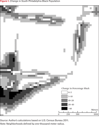
To illustrate the effect of non-Euclidean smoothing, figure 1 presents a map of the change in the percentage black for a neighborhood in South Philadelphia (Point Breeze), which I discuss in more detail later. Areas in where the map is shaded are locations where the percentage black grew or shrank substantially (at least 5 percent) simply due to the inclusion of the borders in the calculation. In this example, the neighborhood’s racial composition does not change (Point Breeze remains predominantly black and the surrounding neighborhoods remain predominantly white), but incorporating non-Euclidean smoothing heightens the contrast at borders between neighborhoods. Traditional kernel density smoothing visualizes artificially smooth transitions between majority black and majority white neighborhoods where non-Euclidean smoothing is able to identify the more sudden demographic shifts at neighborhood boundaries.
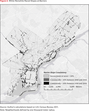
Although barriers normally change slopes over time, some barriers have consistently steep slopes. Identifying those barriers that are consistent racial boundaries may have implications for understanding why certain areas resist racial turnover and what may help spur desegregation efforts in those communities and neighborhoods. Figure 2 shows which barriers have high racial slopes between 1990 and 2010 (persistent slopes) or between 2000 and 2010 (newly formed, persistent slopes). I define a high slope as one above 10 percent. This means that crossing a barrier generally leads to a roughly 20 percent difference in the percentage nonwhite across both sides of the barrier. The large majority of barrier cells are not consistently high, especially in West Philadelphia and North Philadelphia—both highly segregated, predominantly black areas of the city.
Excluding those at the political boundaries of Philadelphia, few barriers act as consistent racial boundaries between 1990 and 2010. Due to that scarcity of consistently high slopes inside the city limits, it is hard to identify specific barriers of interest from figure 2, but some larger patterns do emerge. Generally, most barriers that were consistent in 1990 and 2000 stayed that way through 2010—about 85 percent of the cells identified as consistently high were categorized as such across all three decades (again, many of these barriers are located at Philadelphia’s political boundaries and not between its neighborhoods). This indicates that racial boundaries are either easily overwhelmed over relatively brief periods (ten years) or are hardly penetrable, and few boundaries separate them. As an exploratory analysis, mapping boundaries can identify specific neighborhoods from whose history one can generate hypotheses about why some boundaries are consistent and others are readily crossed. Excluding political boundaries and the center city business area, where the extreme density of major roads and Philadelphia’s Chinatown make it appear heavily bounded, three areas of the city have significant concentrations of consistent boundaries: West Mount Airy, Fishtown/Port Richmond, and South Philadelphia/Point Breeze. These areas were also sites of unique racial histories—specifically, collective white racial reactions to black in-migration in the 1950s and 1960s—that help explain the consistency of their barriers.
WEST MOUNT AIRY: CONSCIOUS INTEGRATION, BUT FOR HOW LONG?
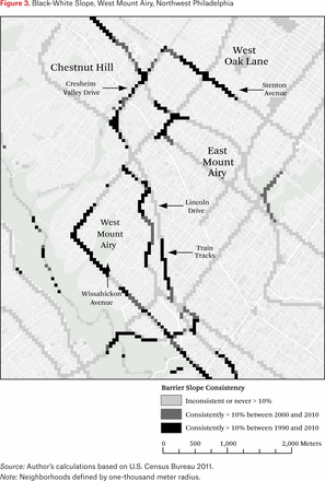
Figure 3 focuses on West Mount Airy, a neighborhood that prides itself on being purposefully integrated since the 1950s; the United Nations sent delegates to the neighborhood to witness that integration in 1961 (Ferman, Singleton, and DeMarco 1998; Perkiss 2014). As large numbers of Philadelphia’s black elite moved in, local groups in West Mount Airy went door to door to combat realtor efforts to blockbust the neighborhood (Perkiss 2014). West Mount Airy spent the 1950s and 1960s creating a collective identity as an integrated community; it consciously became a defended space of integration in a city otherwise actively segregating its growing black population (Hunter 1982; Massey and Denton 1993).
Unfortunately, West Mount Airy appears to be sliding toward internal segregation. The areas in the northern section of the map are the main dividing lines between Chestnut Hill, a wealthy white area, and West Oak Lane, a predominantly black, middle-class neighborhood. More importantly for West Mount Airy, the two black parts of West Mount Airy are isolated from the majority white area by barriers with steep slopes; Wissahickon Avenue is a consistent barrier across all three census periods and Lincoln Drive (the S-shaped curve in the middle of the map) becomes a steep racial boundary in 2000 and stays that way in 2010 (parts of Lincoln Drive were boundaries in 1990, but the whole stretch became a steep boundary only in 2000). Part of this divide corresponds to the type of housing stock available; the housing west of Lincoln Drive is generally large, detached single-family houses, and to the east it is generally smaller and attached row homes. Where Lincoln Drive is not a steep boundary near the southern edge of West Mount Airy, commuter train tracks replace Lincoln Drive as such. Importantly, although Wissahickon Avenue and Lincoln Drive also double as census tract boundaries, the SEPTA train tracts do not. Similarly, in South Philadelphia and Fishtown, I also identify racial boundaries—25th street, sections of Front Street, and Frankford Avenue—that do not double as census tract boundaries.
In West Mount Airy, class appears to be strongly associated with race, because local leaders have expressed concern over economic segregation leading to racial resegregation, even in an area nationally known for a proud history of integration (Smith 2014). The divide often corresponds to the type of housing stock available, as described in the previous paragraph. In areas where two groups with very disparate wealth statuses exist near one another, the wealthier group’s advantages allow it to self-segregate. As income inequality and segregation has grown over time, West Mount Airy has grown more economically segregated, much like the rest of society (Reardon and Bischoff 2011), which has led to an emergence of racial segregation. In northwest Philadelphia, race and class are bounded together.
West Mount Airy’s relatively privileged residents promoted integration and succeeded for at least two generations in perpetuating it, but the more common form of white collective action in Philadelphia and throughout the country in the 1960s was racial violence or flight in support of segregation. Philadelphia—and West Mount Airy—lost the majority of its white population to the suburbs beginning in the 1960s and, even as Philadelphia’s population grew between 2000 and 2010, its white population continues to shrink. Because of this, most neighborhoods that experienced black in-migration in Philadelphia do not have consistent racial barriers because whites generally vacate those neighborhoods when nonwhite populations move in.
BATTLE LINES THEN AND NOW: SOUTH PHILADELPHIA AND FISHTOWN AS DEFENDED COMMUNITIES
The exceptions to that general pattern are the foci of the next figures; both neighborhoods were epicenters of the most aggressive white racial violence in Philadelphia in the 1960s and continued racial tensions since then. Echoing Owens’s research in this volume, which shows how school boundaries act as a sorting mechanism for residential segregation, in South Philadelphia, that racial violence was in response to black efforts to integrate and white efforts to close Bok High School—then largely black and underachieving and closed in 2013 on the basis of school budget deficits—located five blocks east of Broad Street in the heart of Italian South Philadelphia, the political home of notorious law-and-order police commissioner turned mayor Frank Rizzo (Countryman 2005). In 1968, when Rizzo was police commissioner, it was the site of intense racial violence, of police protection for students using public transportation to attend school, and of veiled racial threats by local Italian American residents about making Bok “for South Philadelphians” (Countryman 2005, 245–53). At the height of the crisis, due to fears of further violence, fewer than 25 percent of Bok’s majority black students and fewer than 20 percent of the predominantly white Southern High School attended school.
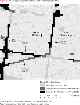
Figures 4 and 5 take a closer look at South Philadelphia, specifically focused on the boundaries surrounding the predominantly black and high-poverty Point Breeze section of the city. Figure 4 identifies steep black-white slopes, which starkly identifies Broad Street as a substantial racial boundary in South Philadelphia. The largely black Point Breeze neighborhood (west of Broad) is bounded to the South from the predominantly white Girard Estates neighborhood by two barriers, Snyder Avenue, which first became a census tract boundary in 2000, and West Passyunk Avenue, and the southern part of 25th Street, which does not extend far north. Broad Street is a consistently steep barrier as well for whites, who primarily live east of it, leaving Point Breeze economically neglected and isolated next to the reinvigorated, traditionally Italian eastern part of South Philadelphia. In sum, from figure 4, it appears that Point Breeze is hemmed in on three sides with regard to the white population in the area.
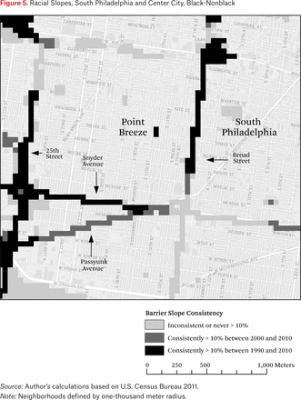
Unlike West Mount Airy, South Philadelphia has experienced substantial immigration, especially from Mexico and Southeast Asia. Figure 5, which focuses on black-nonblack boundaries, shows the impact of that immigration. The southern part of Broad Street where Snyder and Broad meet is now an inconsistent barrier because the large Asian immigration just west of Broad Street and the Hispanic and Asian immigration into the eastern side of South Philadelphia just north of Snyder Avenue have created a more multiracial area with gentler slopes, a potential example of the global neighborhoods that John Logan and Charles Zhang identify (2010, 2011). The lack of barriers to the north of Point Breeze helps explain why gentrification has slowly spread from north to south rather than from east to west. No major road separates the wealthy Rittenhouse area of center city from the southwest part of South Philadelphia. Because of this, gentrification and redevelopment followed a direct route from center city to the area now known as Graduate Hospital through to Point Breeze.
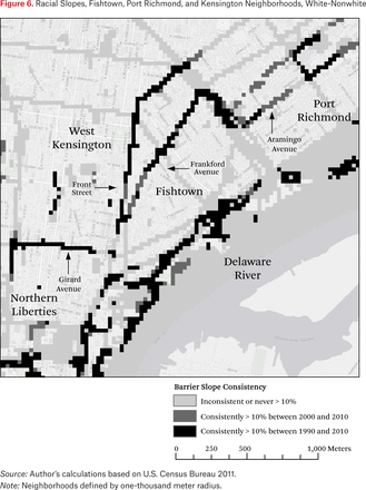
The final maps, figures 6 through 8, look at a third set of neighborhoods with historic identities. Port Richmond and Fishtown on the Delaware River have long histories as white working-class neighborhoods that included large Polish and Russian immigrant communities throughout the twentieth century. To their west lies Kensington, a previously white working-class community that experienced racial turnover in the 1950s and 1960s into a largely black and then Hispanic community. Even more overtly than South Philadelphia, Fishtown and Port Richmond were the sites of significant racial protests against black in-migration and were notorious in Philadelphia for their insular community and “unofficial curfew” for blacks, and for a week-long riot in 1966 when a black family moved near Kensington Girls High (Wolfinger 2007, 185–86). Figure 6 shows that the white populations of Fishtown and Port Richmond are bounded by major roads, as Frankford Avenue and then Aramingo Avenue have consistently steep racial slopes. Frankford Avenue, along with the elevated subway line above North Front Street, is consistently steep from 1990 through 2010; Aramingo Avenue is only consistently steep in 2000 and 2010 because the eastern parts of Kensington were just beginning to see significant Hispanic in-migration in the late 1980s and 1990. That in-migration, too, was met with substantial racial and ethnic violence as the growing Latino population moved further east (Lin 1993). To the south, Girard Avenue divides Northern Liberties, a major hub of redevelopment and gentrification, from the blighted areas of South Kensington.
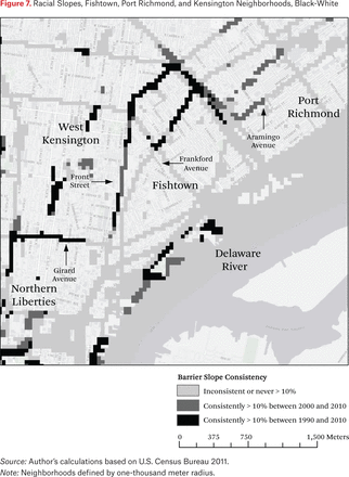
Figure 7 shows that the steep slopes for white-nonwhite racial change are not related to black-white divides. Most of the consistency found in figure 6 disappears. There is still a divide on Front Street, and the division between North Liberties and South Kensington is consistent. In addition, a new slope is identified in the north between the largely black and Hispanic Harrowgate neighborhood and the rest of Northeast Philadelphia, a predominantly white area. This consistency was not identified in the white-nonwhite map because a growing Hispanic and Asian population has been moving into the areas north of Harrowgate—and the black population of Harrowgate has expanded northward.
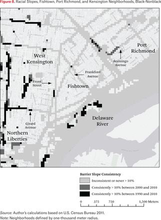
Figure 8, which presents black-nonblack racial slopes, clarifies the role of neighborhood boundaries for the black population in North Philadelphia. Because the Kensington section of Philadelphia is a large hub of Hispanic immigration, the slopes protecting white neighborhoods like Port Richmond and Fishtown are divides not between black and white but instead between white and Hispanic. In figure 8, then, none of the barriers discussed earlier are consistent. Instead, the bulk of the slope consistency between black and nonblack areas are to the west, particularly defined by commuter railroad tracks that isolate black neighborhoods from areas experiencing Hispanic immigration and infusion of capital, and from the neighborhoods around Temple University, which are undergoing substantial improvement due to efforts by the university. The black population in that section of North Philadelphia is missing the redevelopment of North Philadelphia in two directions. To the west, railroad tracks divide it from the reinvestment spurred by Temple, and though the gentrification of Fishtown may spread west into Kensington, that area is now primarily Hispanic.
DISCUSSION
Albert Hunter’s (1982) work on symbolic communities points to a potential explanation for why certain barriers are consistent racial boundaries. Hunter argues that physical barriers made it easier for residents of Chicago to identify the boundaries of their smaller community. Those areas without clear physical boundaries may also lack the social cohesion and identity to create behavioral differences or symbolic meanings to specific roads, which may lead to the types of contested boundaries that are associated with conflict (Legewie and Schaeffer 2016). In Philadelphia, neighborhoods’ ethnic identities, their physical barriers, and cultural identities in the 1960s and 1970s may help explain why those areas avoided the racial turnover other similar neighborhoods experienced, at least partially given the history of racial violence in those neighborhoods that linger today (Wolfinger 2007; Countryman 2005; Lin 1993).
Good fences may make good neighbors, but, as the case study of Philadelphia racial segregation shows, good neighborhood fences are created by perceptions of “bad” neighbors and have long-lasting shadows that extend beyond racial segregation, and have shaped the location of gentrification, commercial investment, and population growth in the city. Racial residential segregation boundaries orient and abet other inequalities by reifying differences between otherwise similar urban spaces. Recently, Point Breeze has become a focal point of intracommunity debate (as well as vandalism and accusations of racism) as the extensive gentrification that began in the early 2000s to its north and east has only now begun to make much delayed inroads into the neighborhood (Zuylen-Wood 2013). West Mount Airy is now struggling to ensure that affordable housing can stem a slide toward racial segregation caused by economic inequality. Fishtown is in the midst of a commercial and residential boom but continues to be a white enclave with few signs of diversification; neighboring Kensington remains largely untouched by the wave of investment and revitalization occurring to its south and west that is anchored in Fishtown. Where the general story in Philadelphia is one of racial turnover in neighborhoods that occurs without being shaped by sharp and persistent boundaries, much like Robert Sampson (2012) shows in Chicago, the legacy of ghettoization adjacent to “defended neighborhoods” (Suttles 1972) of the mid-twentieth century lasts into the twenty-first century.
More broadly, racial residential segregation can be thought of as built on two related but separate geographic processes: clustering within a neighborhood and defining that area’s boundaries. Similarly, Galster’s original theory of neighborhood as externality space considers externality spaces “from the perspective of a particular individual” (1986, 247), but also asserts that the boundaries of that space are critical to identifying and measuring externality spaces. This article presents a novel way of studying and measuring externality spaces that can identify locations for potential targeted policy interventions. From an exploratory analysis of Philadelphia’s racial boundaries as an example of an externality space, I argue that white collective action during black in-migration may explain the location of persistent barriers. Future research should test this hypothesis in other cities and expand to other externalities such as income inequality.
Although this article presents an innovative quantitative methodology to analyze the spatial pattern of racial boundaries, it has limitations. First, the census definitions of major roads may be inaccurate and can miss roads with important local meanings. For example, Washington Avenue is a four-lane road that local residents consider to be a dividing line between neighborhoods. However, it is defined as a tertiary street by the census. Had Washington Avenue been identified as a major road like other roads of its size, the black neighborhood of Point Breeze would likely have been surrounded by steep racial boundaries in all four directions. This article also treats all possible boundary raster cells as equally difficult to cross even though the analysis shows that not all barriers are equally important racial boundaries. Future research should study which types of boundaries are more difficult to cross and test whether incorporating different friction values leads to substantively different results. Finally, many barriers are located near each other; for example, major roads lie on both sides of the Schuylkill River and thus may lower the average impact of barriers on racial slopes incorrectly. In that case, the roads would be the racial boundaries, even though it is the existence of the river that both divides the neighborhoods on each side and led to the construction of roads at that location.
Grannis (2009) shows that small interventions such as changed traffic patterns and improved signage can also change the social dynamics in and around major roads. That small shifts in the role of physical barriers can have dramatic impact on the local spatial opportunity structure is a valuable rejoinder to a sociology that has long treated the neighborhood—and, by extensions, neighborhood boundaries—as relatively static. Neighborhood shapes and racial boundaries change over time and that change should be considered more frequently and in a more dynamic way than traditional sociological methods provide (Bader 2010). Those few locations that have consistent barriers could be recast as locations rife with opportunity for shared use across racial and economic boundaries. Future research should use this method for comparison of urban areas to determine whether Philadelphia’s demographics and urban layout contribute to the number and locations of persistent racial boundaries. It may be that these boundaries are greater in cities with a different history of white responses to nonwhite in-migration, more sprawl, or a newer, more car-oriented transportation system with greater reliance on large highways or roads such as Los Angeles or Houston.
Socially, having identifiable markers of neighborhood boundaries can help a “symbolic community” cohere and be maintained (Hunter 1982). Michele Lamont (1992, 2000) shows how people from different social classes find moral and symbolic value in their class status; individuals justify their social class by making negative moral judgments about those with objectively “better” or “worse” social class status. Similarly, being able to identify a neighborhood as predominantly black or Latino makes individuals judge its desirability more harshly (Krysan and Farley 2002; Krysan, Farley, and Couper 2008). That effect may be enhanced for neighborhoods with physical barriers. Easily identifiable boundaries mean that the neighborhood is easily defined as well, a useful step before imbuing a space with social and moral valuations. Barriers make it possible to easily and quickly identify “good” or “bad” areas, areas where some are “insiders” or “outsiders”3 and thus become a “defended community” (Suttles 1972). Further, a physical barrier can also impede interaction and allow for mythmaking about people from “the other side of the tracks.”
Spatial analysis in the social sciences has primarily focused on the experiences within a single spatial unit. Spatial inequality operates not only by clustering individuals together into one spatial opportunity structure, it is also driven by how groups divide a social space into separate components of that structure (Galster and Sharkey, this volume). This article offers a way to systematically identify how two or more spatial attributes of that structure interact by identifying externality boundaries and the consistency of those boundaries over time without relying on traditional a priori definitions of neighborhoods that introduce unknown error into the analysis. The physical geography of a given space and the collective efforts of residents to define neighborhoods as racially inclusive or exclusive cumulatively created contours of the spatial opportunity structure of Philadelphia’s neighborhoods that last for generations.
Such contours of the spatial opportunity structure likely are a reality in all metro areas. Robert Moses’s infamous decision to build the Cross-Bronx Expressway directly through the Bronx left a legacy of decay in the South Bronx is but the most famous example of the impact of physical boundaries on urban development patterns. That example is of a newly constructed highway and the use of eminent domain (for another, of how even proposing similar projects can affect investment patterns, see Hunter 2013). This article shows that long-lasting racial boundaries can and do emerge more organically as well. As the Philadelphia case demonstrates, local response to efforts to integrate continue to shape where racial segregation boundaries exist for generations without government involvement.
Although this article focuses on racial residential segregation, the methodology introduced here can be used to study other spatial structure or process that involves an interaction between two variables. For example, access to major roads or mass transit may benefit residents who use that transportation to expand their daily activity space to access more distant job markets or educational opportunities. Barriers-based analyses can also explore how land use is associated with differences in crime spillover across neighborhood boundaries, or which local housing submarket values shift in tandem or separately. More broadly, this article is an example of why scholars of spatial inequality and policymakers can and should focus not only on how and where the urban spatial opportunity structure operates by clustering individuals together, but also on how and where divisions within that structure emerge and persist.
Acknowledgments
The author thanks Camille Charles, Tukufu Zuberi, Grace Kao, Tara Jackson, Lindsay Mack, and Brianna Remster for their comments on earlier drafts. The editors of this issue, participants at the Russell Sage Foundation conference “Foundations of Spatial Inequality,” and two anonymous reviewers also provided important feedback on this article. Dana Tomlin provided invaluable support in writing and testing the python script utilized in this article.
FOOTNOTES
↵1. The census defines major roads as arterial roads, often those with more than two lanes or that are highly trafficked.
↵2. I define nonresidential spaces as any census block in which the population is zero. This includes large, block-sized commercial malls but not mixed-use spaces, industrial parks, hospitals, and other block-sized institutions like major government offices. Many of these spaces are adjacent to major roads or are single blocks in the middle of neighborhoods and thus have little impact on the results shown; some major industrial parks in the Southwest of Philadelphia (including oil refineries) and two major airports would otherwise bias results toward greater integration (Grengs 2007).
↵3. A parallel logic exists in how cities are divided into different gang turfs defined by their barriers and many gangs are named after major roads or barriers that they claim as part of their turf.
- © 2017 Russell Sage Foundation. Kramer, Rory. 2017. “Defensible Spaces in Philadelphia: Exploring Neighborhood Boundaries Through Spatial Analysis.” RSF: The Russell Sage Foundation Journal of the Social Sciences 3(2): 81–101. DOI: 10.7758/RSF.2017.3.2.04. The author thanks Camille Charles, Tukufu Zuberi, Grace Kao, Tara Jackson, Lindsay Mack, and Brianna Remster for their comments on earlier drafts. The editors of this issue, participants at the Russell Sage Foundation conference “Foundations of Spatial Inequality,” and two anonymous reviewers also provided important feedback on this article. Dana Tomlin provided invaluable support in writing and testing the python script utilized in this article. Direct correspondence to: Rory Kramer at rory.kramer{at}villanova.edu, Department of Sociology and Criminology, Villanova University, 800 E. Lancaster Avenue, Villanova, PA 19085.
Open Access Policy: RSF: The Russell Sage Foundation Journal of the Social Sciences is an open access journal. This article is published under a Creative Commons Attribution-NonCommercial-NoDerivs 3.0 Unported License.


